File:China Map 1717 Shandong.jpg
Jump to navigation
Jump to search
No higher resolution available.
China_Map_1717_Shandong.jpg (503 × 307 pixels, file size: 102 KB, MIME type: image/jpeg)
Captions
Captions
Add a one-line explanation of what this file represents
Summary
[edit]
| Description |
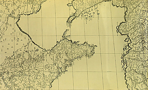
English: A map of Bohai Bay surrounded by the Shandong, Beizhili, and Liaoning provinces of the Qing Empire, from the 1719 copperplate edition of the Kangxi Atlas (皇輿全覽圖, Huangyu Quanlan Tu).
中文:皇輿全覽圖(清內府一統輿地秘圖局部,四排二號,山東半島、遼東半島、朝鮮半島),52.5×77釐米,公元1717年(康熙五十六年)成圖,公元1719年(康熙五十八年)製成銅版,比例尺1:1400000。
《皇輿全覽圖》由清康熙帝主持,中西方測繪人員合作,歷時十年製成,是中國第一部實測全國地圖。以北京經線為本初子午線,採用經緯各差一度的梯形網格。邊疆地區採用滿文標註,關內地區採用漢文標註。該圖具有較高的精度,因此成為公元1933年(民國二十二年)申報館《中華民國新地圖》出版前的很多中國地圖藍本。公元1717年(康熙五十六年)成圖,公元1719年(康熙五十八年)製成銅版,52.5×77釐米,比例尺1:1400000,共41幅,現藏於北京圖書館。 |
| Date | |
| Source | 香港浸會大學地理系中國古地圖 |
| Author |
Licensing
[edit]
|
This work is in the public domain in its country of origin and other countries and areas where the copyright term is the author's life plus 100 years or fewer. | |
| This file has been identified as being free of known restrictions under copyright law, including all related and neighboring rights. | |
File history
Click on a date/time to view the file as it appeared at that time.
| Date/Time | Thumbnail | Dimensions | User | Comment | |
|---|---|---|---|---|---|
| current | 00:35, 19 December 2005 | | 503 × 307 (102 KB) | R.O.C (talk | contribs) | zh: 皇輿全覽圖(清內府一統輿地秘圖局部,四排二號,山東半島、遼東半島、朝鮮半島),52.5×77釐米,公元1717年(康熙五十六年)成圖,公元1719年(康熙五十八年)製成銅版,比例尺1:1400000� |
You cannot overwrite this file.
File usage on Commons
There are no pages that use this file.
File usage on other wikis
The following other wikis use this file: