File:Chesterfield 2 railway station geograph-2151268.jpg
Jump to navigation
Jump to search

Size of this preview: 800 × 513 pixels. Other resolutions: 320 × 205 pixels | 640 × 410 pixels | 1,024 × 656 pixels.
Original file (1,024 × 656 pixels, file size: 221 KB, MIME type: image/jpeg)
Captions
Captions
Add a one-line explanation of what this file represents
Summary
[edit]
| Description |
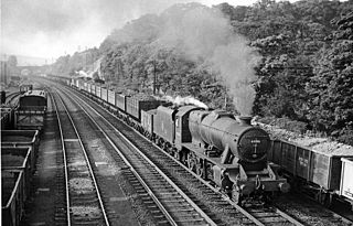
English: Up coke train approaching Chesterfield Midland Station. View northward, towards Tapton Junction, Sheffield etc.; ex-Midland main north-south trunk line. This train, headed by Stanier 8F 2-8-0 No. 48186 and formed of high-capacity coke wagons, followed soon after the Up express in SK3871 : Up express approaching Chesterfield (Midland) Station - and the iron ore train on the Down Slow has not moved yet. |
| Date | Taken on 13 June 1957 |
| Source | From geograph.org.uk |
| Author | Ben Brooksbank |
| Permission (Reusing this file) |
Creative Commons Attribution Share-alike license 2.0 |
| Attribution (required by the license) | Ben Brooksbank / Up coke train approaching Chesterfield Midland Station / |
| Camera location | | View this and other nearby images on: OpenStreetMap |
|---|
Licensing
[edit]

|
This image was taken from the Geograph project collection. See this photograph's page on the Geograph website for the photographer's contact details. The copyright on this image is owned by Ben Brooksbank and is licensed for reuse under the Creative Commons Attribution-ShareAlike 2.0 license.
|
This file is licensed under the Creative Commons Attribution-Share Alike 2.0 Generic license.
Attribution: Ben Brooksbank
- You are free:
- to share – to copy, distribute and transmit the work
- to remix – to adapt the work
- Under the following conditions:
- attribution – You must give appropriate credit, provide a link to the license, and indicate if changes were made. You may do so in any reasonable manner, but not in any way that suggests the licensor endorses you or your use.
- share alike – If you remix, transform, or build upon the material, you must distribute your contributions under the same or compatible license as the original.
File history
Click on a date/time to view the file as it appeared at that time.
| Date/Time | Thumbnail | Dimensions | User | Comment | |
|---|---|---|---|---|---|
| current | 15:07, 9 November 2010 | | 1,024 × 656 (221 KB) | Chevin (talk | contribs) | == {{int:filedesc}} == {{Information |Description={{en|1=Up coke train approaching Chesterfield Midland Station View northward, towards Tapton Junction, Sheffield etc.; ex-Midland main north-south trunk line. This train, headed by Stanier 8F 2-8-0 No. 481 |
You cannot overwrite this file.
File usage on Commons
There are no pages that use this file.
File usage on other wikis
The following other wikis use this file:
- Usage on ar.wikipedia.org
- Usage on en.wikipedia.org