File:Chester Road, Saltney looking west - geograph.org.uk - 285903.jpg
Jump to navigation
Jump to search
Size of this preview: 450 × 600 pixels. Other resolutions: 180 × 240 pixels | 480 × 640 pixels.
Original file (480 × 640 pixels, file size: 184 KB, MIME type: image/jpeg)
Captions
Captions
Add a one-line explanation of what this file represents
Summary
[edit]
| Description |
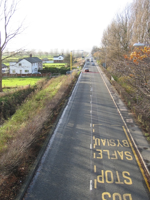
English: Chester Road, Saltney looking west Taken from the footbridge over the A5104, this carriage road, dating from at least the 18th century, has been built on an embankment over the Saltney Marshes. Although now drained, the low-lying fields on either side are still prone to flooding. |
| Date | |
| Source | From geograph.org.uk |
| Author | John S Turner |
| Attribution (required by the license) | John S Turner / Chester Road, Saltney looking west / |
| Camera location | | View this and other nearby images on: OpenStreetMap |
|---|
_heading:247.00&language=en)
| Object location | | View this and other nearby images on: OpenStreetMap |
|---|
_heading:247.00&language=en)
Licensing
[edit]

|
This image was taken from the Geograph project collection. See this photograph's page on the Geograph website for the photographer's contact details. The copyright on this image is owned by John S Turner and is licensed for reuse under the Creative Commons Attribution-ShareAlike 2.0 license.
|
This file is licensed under the Creative Commons Attribution-Share Alike 2.0 Generic license.
Attribution: John S Turner
- You are free:
- to share – to copy, distribute and transmit the work
- to remix – to adapt the work
- Under the following conditions:
- attribution – You must give appropriate credit, provide a link to the license, and indicate if changes were made. You may do so in any reasonable manner, but not in any way that suggests the licensor endorses you or your use.
- share alike – If you remix, transform, or build upon the material, you must distribute your contributions under the same or compatible license as the original.
File history
Click on a date/time to view the file as it appeared at that time.
| Date/Time | Thumbnail | Dimensions | User | Comment | |
|---|---|---|---|---|---|
| current | 19:02, 14 December 2010 | | 480 × 640 (184 KB) | GeographBot (talk | contribs) | == {{int:filedesc}} == {{Information |description={{en|1=Chester Road, Saltney looking west Taken from the footbridge over the A5104, this carriage road, dating from at least the 18th century, has been built on an embankment over the Saltney Marshes. Alt |
You cannot overwrite this file.
File usage on Commons
There are no pages that use this file.