File:Chesil street car park.jpg
From Wikimedia Commons, the free media repository
Jump to navigation
Jump to search
Chesil_street_car_park.jpg (640 × 427 pixels, file size: 122 KB, MIME type: image/jpeg)
File information
Structured data
Captions
Captions
Add a one-line explanation of what this file represents
DescriptionChesil street car park.jpg |
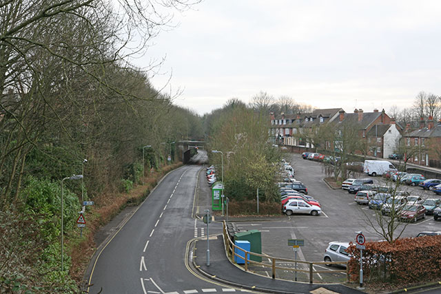
English: Chesil Street car park and old railway line Looking towards Bar End. This is taken as far as practicable from the same position as John Thorn's 1960 photo SU4829 : Railway by Winchester Chesil Station. Winchester Chesil railway station, now a multistorey car park, was behind the photographer. The railway line has become a road. I think John may have taken his photo from the footbridge. |
Date | |
Source | From geograph.org.uk |
Author | Peter Facey |
Permission (Reusing this file) |
Creative Commons Attribution Share-alike license 2.0 |
Attribution (required by the license) InfoField | Peter Facey / Chesil Street car park and old railway line / |
InfoField | Peter Facey / Chesil Street car park and old railway line |
Camera location | 51° 03′ 36.26″ N, 1° 18′ 18.13″ W ![]() | View this and other nearby images on: OpenStreetMap | ![]() |
---|
![]() |
This image was taken from the Geograph project collection. See this photograph's page on the Geograph website for the photographer's contact details. The copyright on this image is owned by Peter Facey and is licensed for reuse under the Creative Commons Attribution-ShareAlike 2.0 license.
|
![w:en:Creative Commons](https://upload.wikimedia.org/wikipedia/commons/thumb/7/79/CC_some_rights_reserved.svg/90px-CC_some_rights_reserved.svg.png)
![attribution](https://upload.wikimedia.org/wikipedia/commons/thumb/1/11/Cc-by_new_white.svg/24px-Cc-by_new_white.svg.png)
![share alike](https://upload.wikimedia.org/wikipedia/commons/thumb/d/df/Cc-sa_white.svg/24px-Cc-sa_white.svg.png)
This file is licensed under the Creative Commons Attribution-Share Alike 2.0 Generic license.
Attribution: Peter Facey
- You are free:
- to share – to copy, distribute and transmit the work
- to remix – to adapt the work
- Under the following conditions:
- attribution – You must give appropriate credit, provide a link to the license, and indicate if changes were made. You may do so in any reasonable manner, but not in any way that suggests the licensor endorses you or your use.
- share alike – If you remix, transform, or build upon the material, you must distribute your contributions under the same or compatible license as the original.
File history
Click on a date/time to view the file as it appeared at that time.
Date/Time | Thumbnail | Dimensions | User | Comment | |
---|---|---|---|---|---|
current | 11:08, 2 October 2008 | ![]() | 640 × 427 (122 KB) | Waggers (talk | contribs) | {{Information |Description=Chesil Street car park and old railway line |Source=From [http://www.geograph.org.uk/photo/107889 geograph.org.uk] |Date=2006-01-18 |Author=[http://www.geograph.org.uk/profile/1533 Peter Facey] |Permission=Creative Commons Attri |
You cannot overwrite this file.
File usage on Commons
There are no pages that use this file.
File usage on other wikis
The following other wikis use this file:
- Usage on en.wikipedia.org
Metadata
This file contains additional information such as Exif metadata which may have been added by the digital camera, scanner, or software program used to create or digitize it. If the file has been modified from its original state, some details such as the timestamp may not fully reflect those of the original file. The timestamp is only as accurate as the clock in the camera, and it may be completely wrong.
Camera manufacturer | Canon |
---|---|
Camera model | Canon EOS 5D |
Exposure time | 1/6 sec (0.16666666666667) |
F-number | f/16 |
ISO speed rating | 100 |
Date and time of data generation | 15:26, 18 January 2006 |
Lens focal length | 50 mm |
Orientation | Normal |
Horizontal resolution | 72 dpi |
Vertical resolution | 72 dpi |
Software used | Adobe Photoshop CS2 Windows |
File change date and time | 16:22, 18 January 2006 |
Y and C positioning | Co-sited |
Exposure Program | Aperture priority |
Exif version | 2.21 |
Date and time of digitizing | 15:26, 18 January 2006 |
Meaning of each component |
|
APEX shutter speed | 2.5 |
APEX aperture | 8 |
APEX exposure bias | 0 |
Metering mode | Pattern |
Flash | Flash did not fire, compulsory flash suppression |
Supported Flashpix version | 1 |
Color space | sRGB |
Focal plane X resolution | 3,086.925795053 |
Focal plane Y resolution | 3,091.2951167728 |
Focal plane resolution unit | inches |
Custom image processing | Normal process |
Exposure mode | Auto exposure |
White balance | Auto white balance |
Scene capture type | Standard |
Supported Flashpix version | 1 |
Image width | 640 px |
Image height | 427 px |
Date metadata was last modified | 16:22, 18 January 2006 |
Structured data
Items portrayed in this file
depicts
some value
51°3'36.263"N, 1°18'18.130"W
18 January 2006
image/jpeg
20c4a0c71907f1ded7124c55e01751f225110fb9
124,483 byte
427 pixel
640 pixel
Hidden categories:
- Information field template with formatting
- Files with coordinates missing SDC location of creation (51° N, 2° W)
- CC-BY-SA-2.0
- Images from Geograph Britain and Ireland
- Images from Geograph Britain and Ireland missing SDC coordinates of depicted place
- Images by Peter Facey
- United Kingdom photographs taken on 2006-01-18