File:Cheltenham (Malvern Road) train from Andover Junction geograph-2683919-by-Ben-Brooksbank.jpg
Jump to navigation
Jump to search

Size of this preview: 800 × 486 pixels. Other resolutions: 320 × 194 pixels | 640 × 389 pixels | 1,024 × 622 pixels | 1,280 × 777 pixels | 2,383 × 1,447 pixels.
Original file (2,383 × 1,447 pixels, file size: 477 KB, MIME type: image/jpeg)
Captions
Captions
Add a one-line explanation of what this file represents
Summary
[edit]_train_from_Andover_Junction_geograph-2683919-by-Ben-Brooksbank.jpg&action=edit§ion=1)
| Description |
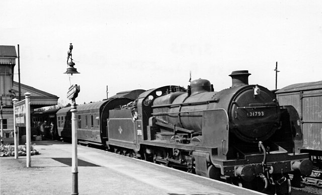
English: Train from Andover Junction at Cheltenham (Malvern Road). View SW, towards Gloucester, also Swindon, Marlborough and Andover: ex-GW Gloucester etc. - Stratford-on-Avon - Birmingham line. Even after Nationalisation the former Midland & South Western Junction Railway trains terminated at the ex-Midland Lansdown station at Cheltenham. Only in the last few years before they ended from 11/9/61 were they diverted to St James' station and - to make matters even more interesting - were worked by the Western Region with SR locomotives. Here, SR Maunsell U class 2-6-0 No. 31793 (built 5/25 as K class 2-6-4T, rebuilt 6/28, withdrawn 5/64) is working the 07.50 from Andover Junction. |
| Date | Taken on 14 April 1959 |
| Source | From geograph.org.uk |
| Author | Ben Brooksbank |
| Permission (Reusing this file) |
Creative Commons Attribution Share-alike license 2.0 |
| Attribution (required by the license) | Ben Brooksbank / Train from Andover Junction at Cheltenham (Malvern Road) / |
| Camera location | | View this and other nearby images on: OpenStreetMap |
|---|
_train_from_Andover_Junction_geograph-2683919-by-Ben-Brooksbank.jpg¶ms=051.898937_N_-002.094711_E_globe:Earth_type:camera_heading:45.00&language=en)
Licensing
[edit]_train_from_Andover_Junction_geograph-2683919-by-Ben-Brooksbank.jpg&action=edit§ion=2)

|
This image was taken from the Geograph project collection. See this photograph's page on the Geograph website for the photographer's contact details. The copyright on this image is owned by Ben Brooksbank and is licensed for reuse under the Creative Commons Attribution-ShareAlike 2.0 license.
|
This file is licensed under the Creative Commons Attribution-Share Alike 2.0 Generic license.
Attribution: Ben Brooksbank
- You are free:
- to share – to copy, distribute and transmit the work
- to remix – to adapt the work
- Under the following conditions:
- attribution – You must give appropriate credit, provide a link to the license, and indicate if changes were made. You may do so in any reasonable manner, but not in any way that suggests the licensor endorses you or your use.
- share alike – If you remix, transform, or build upon the material, you must distribute your contributions under the same or compatible license as the original.
File history
Click on a date/time to view the file as it appeared at that time.
| Date/Time | Thumbnail | Dimensions | User | Comment | |
|---|---|---|---|---|---|
| current | 21:07, 9 November 2011 | | 2,383 × 1,447 (477 KB) | Chevin (talk | contribs) | == {{int:filedesc}} == {{Information |Description={{en|1='''Train from Andover Junction at Cheltenham (Malvern Road).'''<br/> View SW, towards Gloucester, also Swindon, Marlborough and Andover: ex-GW Gloucester etc. - Stratford-on-Avon - Birmingham line. |
You cannot overwrite this file.
File usage on Commons
The following 3 pages use this file:
File usage on other wikis
The following other wikis use this file:
- Usage on en.wikipedia.org
- Usage on www.wikidata.org
_train_from_Andover_Junction_geograph-2683919-by-Ben-Brooksbank.jpg&oldid=855351055)