File:Cheesden Lumb Mill 2007 - geograph.org.uk - 425015.jpg
Jump to navigation
Jump to search
No higher resolution available.
Cheesden_Lumb_Mill_2007_-_geograph.org.uk_-_425015.jpg (640 × 480 pixels, file size: 147 KB, MIME type: image/jpeg)
Captions
Captions
Add a one-line explanation of what this file represents
Summary
[edit]
| Description |
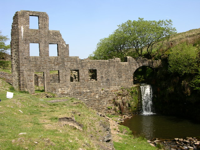
English: Cheesden Lumb Mill 2007. This former woollen mill was built in 1786, just below the confluence of Cheesden Brook and Kilgate Brook. At first it was a fulling mill, but it later extended its activities to include carding, bleaching and dyeing. However it later changed to spinning cotton waste, and ended up producing lamp wicks. The mill closed around 1898 and was abandoned(information from Dr Neil Clifton - see photo of Mill from 1952 for contrast322525) |
| Date | |
| Source | From geograph.org.uk |
| Author | liz dawson |
| Attribution (required by the license) | liz dawson / Cheesden Lumb Mill 2007 / |
| Camera location | | View this and other nearby images on: OpenStreetMap |
|---|
_heading:22.00&language=en)
| Object location | | View this and other nearby images on: OpenStreetMap |
|---|
_heading:22.00&language=en)
Licensing
[edit]

|
This image was taken from the Geograph project collection. See this photograph's page on the Geograph website for the photographer's contact details. The copyright on this image is owned by liz dawson and is licensed for reuse under the Creative Commons Attribution-ShareAlike 2.0 license.
|
This file is licensed under the Creative Commons Attribution-Share Alike 2.0 Generic license.
Attribution: liz dawson
- You are free:
- to share – to copy, distribute and transmit the work
- to remix – to adapt the work
- Under the following conditions:
- attribution – You must give appropriate credit, provide a link to the license, and indicate if changes were made. You may do so in any reasonable manner, but not in any way that suggests the licensor endorses you or your use.
- share alike – If you remix, transform, or build upon the material, you must distribute your contributions under the same or compatible license as the original.
File history
Click on a date/time to view the file as it appeared at that time.
| Date/Time | Thumbnail | Dimensions | User | Comment | |
|---|---|---|---|---|---|
| current | 04:01, 4 February 2011 | | 640 × 480 (147 KB) | GeographBot (talk | contribs) | == {{int:filedesc}} == {{Information |description={{en|1=Cheesden Lumb Mill 2007 This former woollen mill was built in 1786, just below the confluence of Cheesden Brook and Kilgate Brook. At first it was a fulling mill, but it later extended its activitie |
You cannot overwrite this file.
File usage on Commons
There are no pages that use this file.