File:Chechen Republic relief location map.svg
Jump to navigation
Jump to search

Size of this PNG preview of this SVG file: 492 × 599 pixels. Other resolutions: 197 × 240 pixels | 394 × 480 pixels | 631 × 768 pixels | 841 × 1,024 pixels | 1,683 × 2,048 pixels | 6,295 × 7,662 pixels.
Original file (SVG file, nominally 6,295 × 7,662 pixels, file size: 1.62 MB)
Captions
Captions
Add a one-line explanation of what this file represents
Summary
[edit]
| Description |
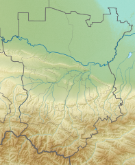
Русский: Позиционная карта Чеченской Республики
Равноугольная проекция, растяжение - 140%. Координаты краёв: |
| Date | |
| Source | Own work File:Chechen_relief.png (Uwe Dedering) |
| Author | Takhirgeran Umar |
Licensing
[edit]
I, the copyright holder of this work, hereby publish it under the following license:
This file is licensed under the Creative Commons Attribution-Share Alike 4.0 International license.
- You are free:
- to share – to copy, distribute and transmit the work
- to remix – to adapt the work
- Under the following conditions:
- attribution – You must give appropriate credit, provide a link to the license, and indicate if changes were made. You may do so in any reasonable manner, but not in any way that suggests the licensor endorses you or your use.
- share alike – If you remix, transform, or build upon the material, you must distribute your contributions under the same or compatible license as the original.
File history
Click on a date/time to view the file as it appeared at that time.
| Date/Time | Thumbnail | Dimensions | User | Comment | |
|---|---|---|---|---|---|
| current | 05:57, 18 May 2020 | | 6,295 × 7,662 (1.62 MB) | Takhirgeran Umar (talk | contribs) | прозрачный лист |
| 16:48, 10 April 2020 |  | 6,295 × 7,662 (1.62 MB) | Takhirgeran Umar (talk | contribs) | . | |
| 16:38, 10 April 2020 |  | 6,297 × 7,661 (1.62 MB) | Takhirgeran Umar (talk | contribs) | . | |
| 16:35, 10 April 2020 |  | 6,307 × 7,672 (1.62 MB) | Takhirgeran Umar (talk | contribs) | . | |
| 16:30, 10 April 2020 |  | 6,307 × 7,676 (1.62 MB) | Takhirgeran Umar (talk | contribs) | Uploaded own work with UploadWizard |
You cannot overwrite this file.
File usage on Commons
The following 2 pages use this file:
.svg)
File usage on other wikis
The following other wikis use this file:
- Usage on be.wikipedia.org
- Usage on ce.wikipedia.org
- ТӀуьйли-лам
- Кеп:Меттиган карта
- Кеп:Меттиган карта/doc
- Кеп:Меттиган карта Росси Нохчийчоь
- Кеп:Лам
- Кеп:Лам/doc
- Къоьзана Ӏам
- Дукълуо-Лам
- ГӀачалкхин рагӀ
- Галайн-Ӏам
- Нохчийн аре
- Бенойн лам
- Тумсойн лам
- Орга (эрк)
- Кхел-хи (МаӀа-хин га)
- Даттах-Корта
- Хул-Хуло
- Нохчийчоьнан лаьмнаш
- Садойн-Лам
- Навр-корта
- Донойн-лам
- Чермойн лам
- Гумс
- Ӏаьржа ахк
- Элистанжа (эрк)
- Зуйн ахк
- Кохичу-Ахк
- Аьхкичу
- Мичиг-Хи
- Искаьрк
- ГӀансол
- Хумг
- Теллин-Аьхк
- Ахкие
- Бохь-ЖагӀа
- Типши-ЖагӀа
- Доккха Шовда
- Жима Шовда
- Жалкх (эрк)
- Гурс-Эхк
- МахкатӀан Шовда
- Тениг
- Булкх
- Мелчу-Аьхка
- Тайсун-Эна-Аьхки
- Бенитатол
- Шела-Ахк
View more global usage of this file.