File:Chech 2.png
Jump to navigation
Jump to search

Size of this preview: 800 × 531 pixels. Other resolutions: 320 × 212 pixels | 640 × 425 pixels | 1,024 × 680 pixels | 1,280 × 849 pixels | 2,860 × 1,898 pixels.
Original file (2,860 × 1,898 pixels, file size: 147 KB, MIME type: image/png)
Captions
Captions
Add a one-line explanation of what this file represents
| Description |
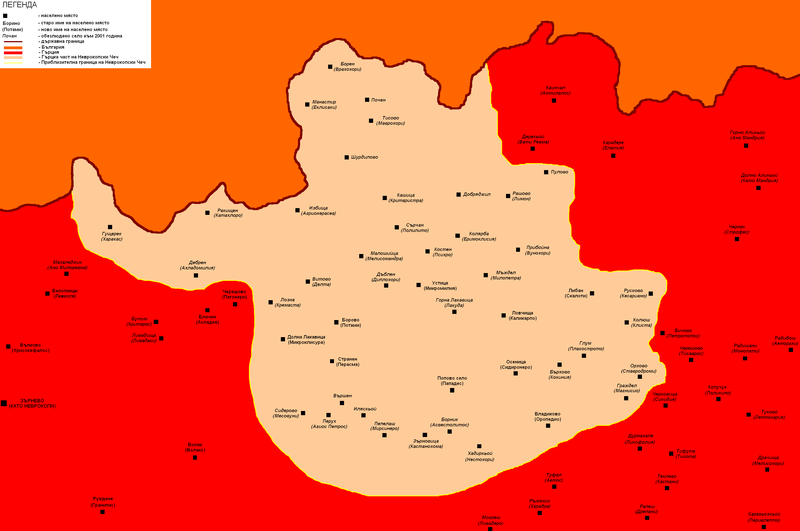
English: An improved map of the Greek Chech with the extinguished villages.
Български: Карта на Чеча.
Борово (Потами) - Населено място България
Гърция
Чеч
Граница между България и Гърция
Граница на Чеч
По-нататъшни задачи:
|
| Date | |
| Source | Own work |
| Author | Chech Explorer |
| Permission (Reusing this file) |
I, the copyright holder of this work, hereby publish it under the following license: This file is licensed under the Creative Commons Attribution-Share Alike 3.0 Unported license.
|
File history
Click on a date/time to view the file as it appeared at that time.
| Date/Time | Thumbnail | Dimensions | User | Comment | |
|---|---|---|---|---|---|
| current | 14:24, 2 July 2009 | | 2,860 × 1,898 (147 KB) | Chech Explorer (talk | contribs) | Updated |
| 11:40, 2 July 2009 |  | 2,860 × 1,898 (161 KB) | Chech Explorer (talk | contribs) | Updated names | |
| 11:13, 5 September 2008 |  | 2,860 × 1,898 (151 KB) | Chech Explorer (talk | contribs) | {{Information |Description={{en|1=An improved map of the Greek Chech with the extinguished villages.}} {{bg|1=Карта на Чеча. '''Борово (Потами)''' - Населено място<br /> '''''Малошийца (Мелисомандр� |
You cannot overwrite this file.
File usage on Commons
There are no pages that use this file.
File usage on other wikis
The following other wikis use this file: