File:Chaumont-sur-Tharonne (Loir-et-Cher) (12815958313).jpg

Original file (4,928 × 3,264 pixels, file size: 9.03 MB, MIME type: image/jpeg)
Captions
Captions
Summary
[edit]_(12815958313).jpg&action=edit§ion=1)
| Description |
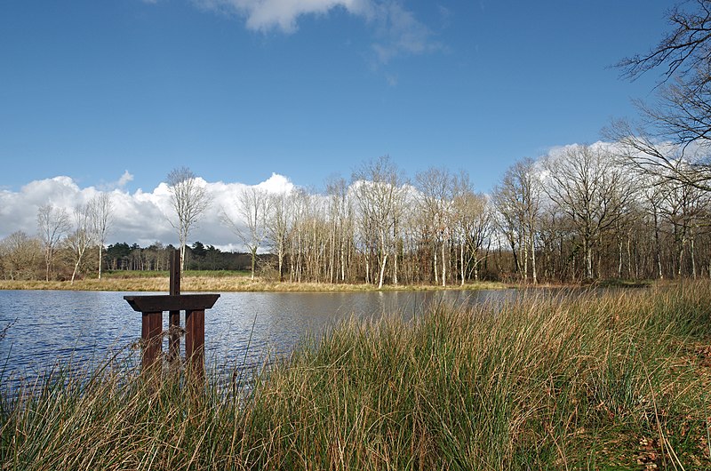
Un étang. Un étang est un plan d’eau artificiel. On barre une petite vallée avec une digue qu’on appelle la chaussée. Une bonde permet de vider l’étang. (Voir le beau travail de l’école de Bauzy sur le sujet : www.icem-pedagogie-freinet.org/sites/default/files/FTJ_22...) Depuis le Moyen-Age, les étangs sont construits en grand nombre en Sologne. À la Renaissance on les estime à 4000. Les étangs sont, à cette époque, d’un grand rapport, un hectare d’étang rapporte 10 fois plus qu’un hectare de terre agricole en Beauce. Avec 140 jours maigres par an, la demande en poissons est grande. Au 16ème siècle, les guerres de religion désorganisent la distribution du poisson et les étangs sont abandonnés. Les étangs se colmatent et deviennent des marécages. Les moustiques pullulent et les fièvres palustres se développent. La misère et les maladies font chuter l’espérance de vie vers 23 ans aux 17ème et 18ème siècles. A la révolution, le décret du 14 frimaire an II décidait l’assèchement des étangs.le décret avait pour objet de « rendre à la santé et à la vie des milliers de Français qui moissonnent, chaque année, avant le terme marqué par la nature des maladies produites par les funestes émanations des étangs ». Le paludisme régressa en Sologne probablement grâce, en partie, à l’apparition de la quinine. Les solognots réexploiteront les étangs. (www.afes.fr/afes/egs/EGS_13_1_fanica.pdf)
Since the Middle Ages, the ponds are built in large numbers in Sologne. During the Renaissance the estimated number of ponds in Sologne at 4000. The ponds are at this period a great resource, one hectare pond earn 10 times more than a hectare of agricultural land in the Beauce. With 140 days of fasting a year, there is a high demand for fish. Religious wars disrupt the distribution of fish, and ponds are abandoned. Ponds clog and become swamps. Mosquitoes proliferate and malarial fevers develop. Poverty and disease are falling life expectancy to 23 years in the 17th and 18th centuries. During the Revolution, the decree of 14 Frimaire II decided drying ponds. The decree was to "make the health and lives of thousands of French people who die each year before the date because of diseases caused by the deadly vapors ponds." Malaria regressed in Sologne probably due in part to the emergence of quinine. The solognots re-exploit ponds. |
| Date | Taken on 26 February 2014, 15:55 |
| Source | Chaumont-sur-Tharonne (Loir-et-Cher) |
| Author | Daniel Jolivet |
| Camera location | | View this and other nearby images on: OpenStreetMap |
|---|
_(12815958313).jpg¶ms=047.615930_N_0001.885052_E_globe:Earth_type:camera_source:Flickr_&language=en)
Licensing
[edit]_(12815958313).jpg&action=edit§ion=2)
- You are free:
- to share – to copy, distribute and transmit the work
- to remix – to adapt the work
- Under the following conditions:
- attribution – You must give appropriate credit, provide a link to the license, and indicate if changes were made. You may do so in any reasonable manner, but not in any way that suggests the licensor endorses you or your use.
| This image was originally posted to Flickr by sybarite48 at https://flickr.com/photos/26082117@N07/12815958313 (archive). It was reviewed on 17 November 2017 by FlickreviewR 2 and was confirmed to be licensed under the terms of the cc-by-2.0. |
File history
Click on a date/time to view the file as it appeared at that time.
| Date/Time | Thumbnail | Dimensions | User | Comment | |
|---|---|---|---|---|---|
| current | 13:37, 17 November 2017 | | 4,928 × 3,264 (9.03 MB) | Thesupermat2 (talk | contribs) | Transferred from Flickr via Flickr2Commons |
You cannot overwrite this file.
File usage on Commons
There are no pages that use this file.
_(12815958313).jpg&oldid=855132927)