File:Chasms and cliffs on Mars ESA15179369.jpeg
Jump to navigation
Jump to search
Size of this preview: 800 × 436 pixels. Other resolutions: 320 × 174 pixels | 640 × 349 pixels | 1,024 × 558 pixels | 1,280 × 697 pixels | 2,560 × 1,395 pixels | 6,607 × 3,600 pixels.
Original file (6,607 × 3,600 pixels, file size: 15.74 MB, MIME type: image/jpeg)
Captions
Captions
Add a one-line explanation of what this file represents
Summary
[edit]
| Description |
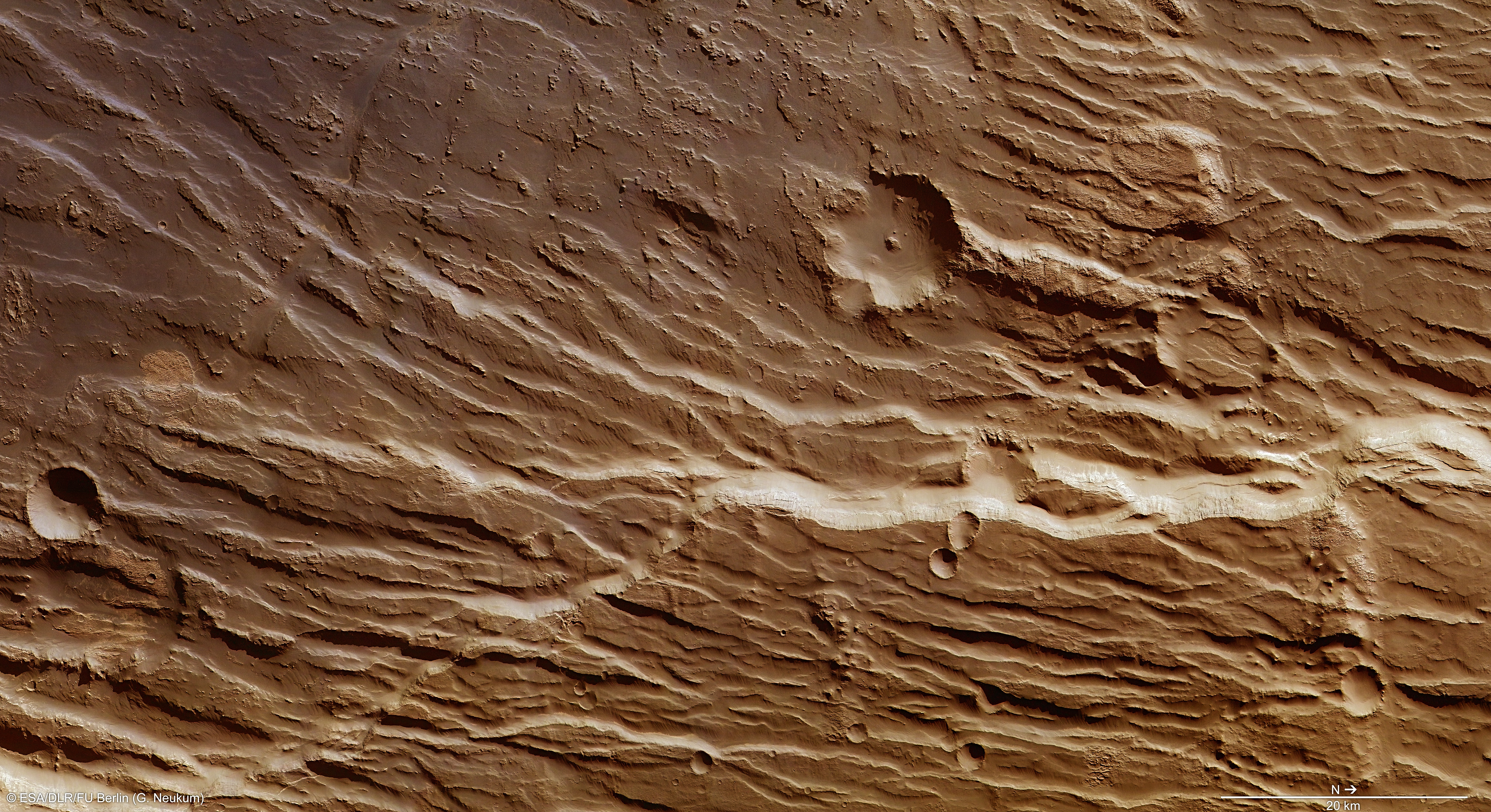
English: Although Mars is a very alien planet, some aspects of its geology are surprisingly familiar. This Mars Express image shows a snippet of a region of Mars filled with cliffs, trenches, faults, giant plateaus and volcanoes. The flowing cracks and fault-like lines in this image form part of the Claritas Rupes escarpment, a 950 km-long network of steep cliffs and sloping outcrops. This escarpment lies within a larger geological system named Claritas Fossae, a weaving network of ‘grabens’ (a German term meaning ditch or trench) that stretches for some 2000 km. The many chasms, fractures and cracks in this area are thought to have been caused by stress in the planet’s crust as it stretched and pulled apart, triggered by the formation of a nearby raised mound known as the Tharsis Bulge. This bulge, located within the volcanic Tharsis region, extends to a height of about 10 km at its peak. Its violent formation caused parts of the crust to crack and shift, sliding into depressions and gaps, forming a distinctive pattern of geological features such as sunken grabens and raised blocks known as ‘horsts’. These two features can be very roughly imagined as an ‘M’ shape – grabens form the bottom of the central dip, while horsts form the two uppermost tips. Similar patterns can be found on Earth around the Upper Rhine Valley between Basel in Switzerland, and Karlsruhe in Germany, or the Eger Graben in the Czech Republic, near the Ore Mountains. Prominent examples of terrestrial grabens include California’s Death Valley, and the Dead Sea depression in the Jordan Rift Valley. Examples of horsts include France’s Vosges Mountains, and the Palestine Plateau. Claritas Rupes forms the eastern boundary of the Tharsis region. This region contains some of the largest volcanoes in the Solar System, including the famous Olympus Mons, which stands some three times the height of Earth’s Mount Everest. This image was acquired by the High Resolution Stereo Camera of Mars Express on 30 November 2013 at a resolution of about 14 m per pixel. It was first published on 13 February 2014 on the DLR German Aerospace Center and Freie Universität Berlin websites. Copyright Notice: This work is licenced under the Creative Commons Attribution-ShareAlike 3.0 IGO (CC BY-SA 3.0 IGO) licence. The user is allowed to reproduce, distribute, adapt, translate and publicly perform this publication, without explicit permission, provided that the content is accompanied by an acknowledgement that the source is credited as 'ESA/DLR/FU Berlin’, a direct link to the licence text is provided and that it is clearly indicated if changes were made to the original content. Adaptation/translation/derivatives must be distributed under the same licence terms as this publication. To view a copy of this license, please visit https://creativecommons.org/licenses/by-sa/3.0/igo/. |
| Date | 5 January 2015 (upload date) |
| Source | Chasms and cliffs on Mars |
| Author | ESA/DLR/FU Berlin |
| Activity | Space Science |
| Mission | Mars Express |
| Set | Space Science image of the week |
Licensing
[edit]
This media was created by the European Space Agency (ESA).
Where expressly so stated, images or videos are covered by the Creative Commons Attribution-ShareAlike 3.0 IGO (CC BY-SA 3.0 IGO) licence, ESA being an Intergovernmental Organisation (IGO), as defined by the CC BY-SA 3.0 IGO licence. The user is allowed under the terms and conditions of the CC BY-SA 3.0 IGO license to Reproduce, Distribute and Publicly Perform the ESA images and videos released under CC BY-SA 3.0 IGO licence and the Adaptations thereof, without further explicit permission being necessary, for as long as the user complies with the conditions and restrictions set forth in the CC BY-SA 3.0 IGO licence, these including that:
See the ESA Creative Commons copyright notice for complete information, and this article for additional details.
|
 | |
This file is licensed under the Creative Commons Attribution-ShareAlike 3.0 IGO license. Attribution: ESA/DLR/FU Berlin, CC BY-SA IGO 3.0
| ||
File history
Click on a date/time to view the file as it appeared at that time.
| Date/Time | Thumbnail | Dimensions | User | Comment | |
|---|---|---|---|---|---|
| current | 21:32, 11 June 2020 | | 6,607 × 3,600 (15.74 MB) | OptimusPrimeBot (talk | contribs) | #Spacemedia - Upload of https://www.esa.int/var/esa/storage/images/esa_multimedia/images/2015/01/chasms_and_cliffs_on_mars/15179360-1-eng-GB/Chasms_and_cliffs_on_Mars.jpg via Commons:Spacemedia |
You cannot overwrite this file.
File usage on Commons
The following 2 pages use this file:
.jpg&redirect=no)