File:Charte over den Danske Oe St Croix i America RMG K0891.jpg
Jump to navigation
Jump to search

Size of this preview: 800 × 589 pixels. Other resolutions: 320 × 236 pixels | 640 × 472 pixels | 1,024 × 754 pixels | 1,280 × 943 pixels.
Original file (1,280 × 943 pixels, file size: 1.02 MB, MIME type: image/jpeg)
Captions
Captions
Add a one-line explanation of what this file represents
Summary
[edit]
| Author |
Angelo; Oxholm, P L |
| Description |
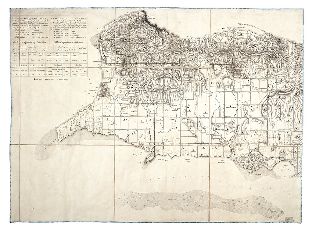
English: Charte over den Danske Oe St Croix i AmericaTwo sheets. Engr. Medium: Segmented and backed. Scale: 1:26 000 (bar). Cartographic Note: North at 21 degrees. Ungraduated, with land relief, soundings and shoals marked. Scale in Danish miles. Additional Places: Caribbean, Virgin Islands. Contents Note: The island was laid out in a rectilinear grid of roads and property boundaries, The title cartouche depicts: black workers receiving orders from a mounted white overseer; a mother with small children outside a tent; men carrying firewood with a donkey and several buildings including a windmill, There is a population table of white', 'coloured' and 'black' inhabitants. Gren82/2(2) Charte over den Danske Oe St Croix i America |
| Date | 1799 |
| Dimensions | Each sheet 63 cm x 83 cm |
| Notes | For an analysis of the bias towards geographical coverage when looking at the contents of the collection see tables from the printed (complete) biography of Grenville. This is kept with the red binders as part of the Grenville collection binder (in SOG). |
| Source/Photographer | http://collections.rmg.co.uk/collections/objects/610267 |
| Permission (Reusing this file) |
The original artefact or artwork has been assessed as public domain by age, and faithful reproductions of the two dimensional work are also public domain. No permission is required for reuse for any purpose. The text of this image record has been derived from the Royal Museums Greenwich catalogue and image metadata. Individual data and facts such as date, author and title are not copyrightable, but reuse of longer descriptive text from the catalogue may not be considered fair use. Reuse of the text must be attributed to the "National Maritime Museum, Greenwich, London" and a Creative Commons CC-BY-NC-SA-3.0 license may apply if not rewritten. Refer to Royal Museums Greenwich copyright. |
| Identifier | GGCC: 245:14 id number: GREN82/2B |
| Collection | Charts and maps |
Licensing
[edit]
|
This is a faithful photographic reproduction of a two-dimensional, public domain work of art. The work of art itself is in the public domain for the following reason:
The official position taken by the Wikimedia Foundation is that "faithful reproductions of two-dimensional public domain works of art are public domain".
This photographic reproduction is therefore also considered to be in the public domain in the United States. In other jurisdictions, re-use of this content may be restricted; see Reuse of PD-Art photographs for details. | ||||
File history
Click on a date/time to view the file as it appeared at that time.
| Date/Time | Thumbnail | Dimensions | User | Comment | |
|---|---|---|---|---|---|
| current | 11:24, 1 September 2017 | | 1,280 × 943 (1.02 MB) | Fæ (talk | contribs) | Royal Museums Greenwich Charts and maps, http://collections.rmg.co.uk/collections/objects/610267 |
You cannot overwrite this file.
File usage on Commons
The following page uses this file: