File:Charles Wilkes-fr.svg
Jump to navigation
Jump to search

Size of this PNG preview of this SVG file: 353 × 431 pixels. Other resolutions: 196 × 240 pixels | 393 × 480 pixels | 629 × 768 pixels | 839 × 1,024 pixels | 1,677 × 2,048 pixels.
Original file (SVG file, nominally 353 × 431 pixels, file size: 4.5 MB)
Captions
Captions
Add a one-line explanation of what this file represents
| Description |
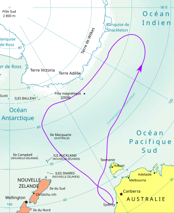
Français : Carte des expéditions en Antarctique de Charles Wilkes : 1839-42.
English: Map of the expeditions in Antarctica of Charles Wilkes : 1839-42.
Deutsch: Karte der Speditionen im Antarktis von Charles Wilkes : 1839-42.
Español: Carta de las expediciones en Antárctico de Charles Wilkes : 1839-42.
Italiano: Mappa delle spedizioni in Antartide di Charles Wilkes : 1839-42.
Русский: Карта экспедиций в Антарктиде Charles Wilkes : 1839-42. |
||
| Date | |||
| Source | travail personnel sur un fond issu de Image:Antarctica.CIA.svg ; les données des trajets proviennent de Bertrand Imbert et Claude Lorius, Le grand défi des pôles, coll. Découvertes Gallimard, série histoire, 1987, réédition 2006 - ISBN 2070530132. | ||
| Author | Bourrichon | ||
| Permission (Reusing this file) |
I, the copyright holder of this work, hereby publish it under the following licenses:
This file is licensed under the Creative Commons Attribution-Share Alike 3.0 Unported, 2.5 Generic, 2.0 Generic and 1.0 Generic license.
You may select the license of your choice. |
||
| Other versions |
|


|
This SVG file contains embedded text that can be translated into your language, using any capable SVG editor, text editor or the SVG Translate tool. For more information see: About translating SVG files. |
This W3C-unspecified vector image was created with Inkscape .
File history
Click on a date/time to view the file as it appeared at that time.
| Date/Time | Thumbnail | Dimensions | User | Comment | |
|---|---|---|---|---|---|
| current | 14:09, 22 April 2008 | | 353 × 431 (4.5 MB) | Bourrichon (talk | contribs) | {{Information |Description= {{fr|Carte des expéditions en Antarctique de Charles Wilkes : 1839-41.}} {{en|Map of the expeditions in Antarctica of Charles Wilkes : 1839-41.}} {{de|Karte der Speditionen im Antarktis von Charles Wilkes : 1839-41.}} {{es|Car |
You cannot overwrite this file.
File usage on Commons
The following 2 pages use this file:
File usage on other wikis
The following other wikis use this file:
- Usage on bg.wikipedia.org
- Usage on cs.wikipedia.org
- Usage on da.wikipedia.org
- Usage on es.wikipedia.org
- Usage on fr.wikipedia.org
- Usage on hu.wikipedia.org
- Usage on ja.wikipedia.org
- Usage on pt.wikipedia.org
- Usage on sv.wikipedia.org