File:Charity Farmhouse - geograph.org.uk - 757399.jpg
Jump to navigation
Jump to search
No higher resolution available.
Charity_Farmhouse_-_geograph.org.uk_-_757399.jpg (640 × 480 pixels, file size: 65 KB, MIME type: image/jpeg)
Captions
Captions
Add a one-line explanation of what this file represents
Summary
[edit]
| Description |
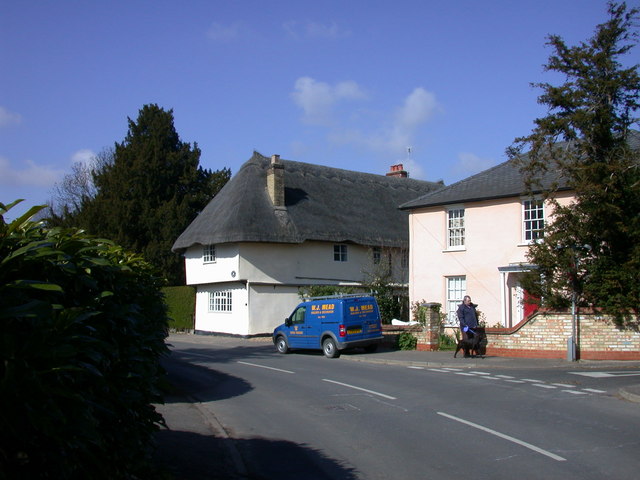
English: Charity Farmhouse Early C16 with later C16 extension to south-east, C19 alterations and conversion to two dwellings, C20 renovation. Timber-framed and plastered, plastered brick plinth, C19 clay bat; and weather boarding. Hipped thatched roof, upper storey jettied to street. Grade II listed. http://www.heritagegateway.org.uk/Gateway/Results_Single.aspx?resourceID=5&uid=53161 |
| Date | |
| Source | From geograph.org.uk |
| Author | Keith Edkins |
| Attribution (required by the license) | Keith Edkins / Charity Farmhouse / |
| Camera location | | View this and other nearby images on: OpenStreetMap |
|---|
_heading:292.00&language=en)
| Object location | | View this and other nearby images on: OpenStreetMap |
|---|
_heading:292.00&language=en)
Licensing
[edit]

|
This image was taken from the Geograph project collection. See this photograph's page on the Geograph website for the photographer's contact details. The copyright on this image is owned by Keith Edkins and is licensed for reuse under the Creative Commons Attribution-ShareAlike 2.0 license.
|
This file is licensed under the Creative Commons Attribution-Share Alike 2.0 Generic license.
Attribution: Keith Edkins
- You are free:
- to share – to copy, distribute and transmit the work
- to remix – to adapt the work
- Under the following conditions:
- attribution – You must give appropriate credit, provide a link to the license, and indicate if changes were made. You may do so in any reasonable manner, but not in any way that suggests the licensor endorses you or your use.
- share alike – If you remix, transform, or build upon the material, you must distribute your contributions under the same or compatible license as the original.
File history
Click on a date/time to view the file as it appeared at that time.
| Date/Time | Thumbnail | Dimensions | User | Comment | |
|---|---|---|---|---|---|
| current | 14:29, 19 February 2011 | | 640 × 480 (65 KB) | GeographBot (talk | contribs) | == {{int:filedesc}} == {{Information |description={{en|1=Charity Farmhouse Early C16 with later C16 extension to south-east, C19 alterations and conversion to two dwellings, C20 renovation. Timber-framed and plastered, plastered brick plinth, C19 clay bat |
You cannot overwrite this file.
File usage on Commons
There are no pages that use this file.
File usage on other wikis
The following other wikis use this file:
- Usage on www.wikidata.org