File:Chaoyang-map.png
Jump to navigation
Jump to search

Size of this preview: 617 × 599 pixels. Other resolutions: 247 × 240 pixels | 494 × 480 pixels | 791 × 768 pixels | 1,054 × 1,024 pixels | 1,500 × 1,457 pixels.
Original file (1,500 × 1,457 pixels, file size: 503 KB, MIME type: image/png)
Captions
Captions
Add a one-line explanation of what this file represents
Summary
[edit]
| Description |
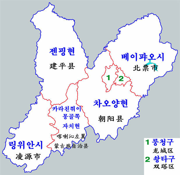
한국어: 차오양시 현급구역도 |
| Date | |
| Source | Own work |
| Author | 장길산 |
Licensing
[edit]
| I, the copyright holder of this work, release this work into the public domain. This applies worldwide. In some countries this may not be legally possible; if so: I grant anyone the right to use this work for any purpose, without any conditions, unless such conditions are required by law. |
File history
Click on a date/time to view the file as it appeared at that time.
| Date/Time | Thumbnail | Dimensions | User | Comment | |
|---|---|---|---|---|---|
| current | 10:45, 5 March 2011 | | 1,500 × 1,457 (503 KB) | Gloyacks (talk | contribs) | 지형조정 |
| 12:13, 16 April 2010 |  | 800 × 377 (79 KB) | Gloyacks (talk | contribs) | {{파일 정보 |설명=차오양시 현급구역도 |출처=자작 |날짜=2010년 4월 16일 |만든이=장길산 |저작권= |기타= }} |
You cannot overwrite this file.
File usage on Commons
There are no pages that use this file.
File usage on other wikis
The following other wikis use this file:
- Usage on ko.wikipedia.org