File:ChangSha Metro Map.png
Jump to navigation
Jump to search
Size of this preview: 788 × 599 pixels. Other resolutions: 316 × 240 pixels | 631 × 480 pixels | 1,010 × 768 pixels | 1,280 × 973 pixels | 2,560 × 1,947 pixels | 3,374 × 2,566 pixels.
Original file (3,374 × 2,566 pixels, file size: 585 KB, MIME type: image/png)
Captions
Captions
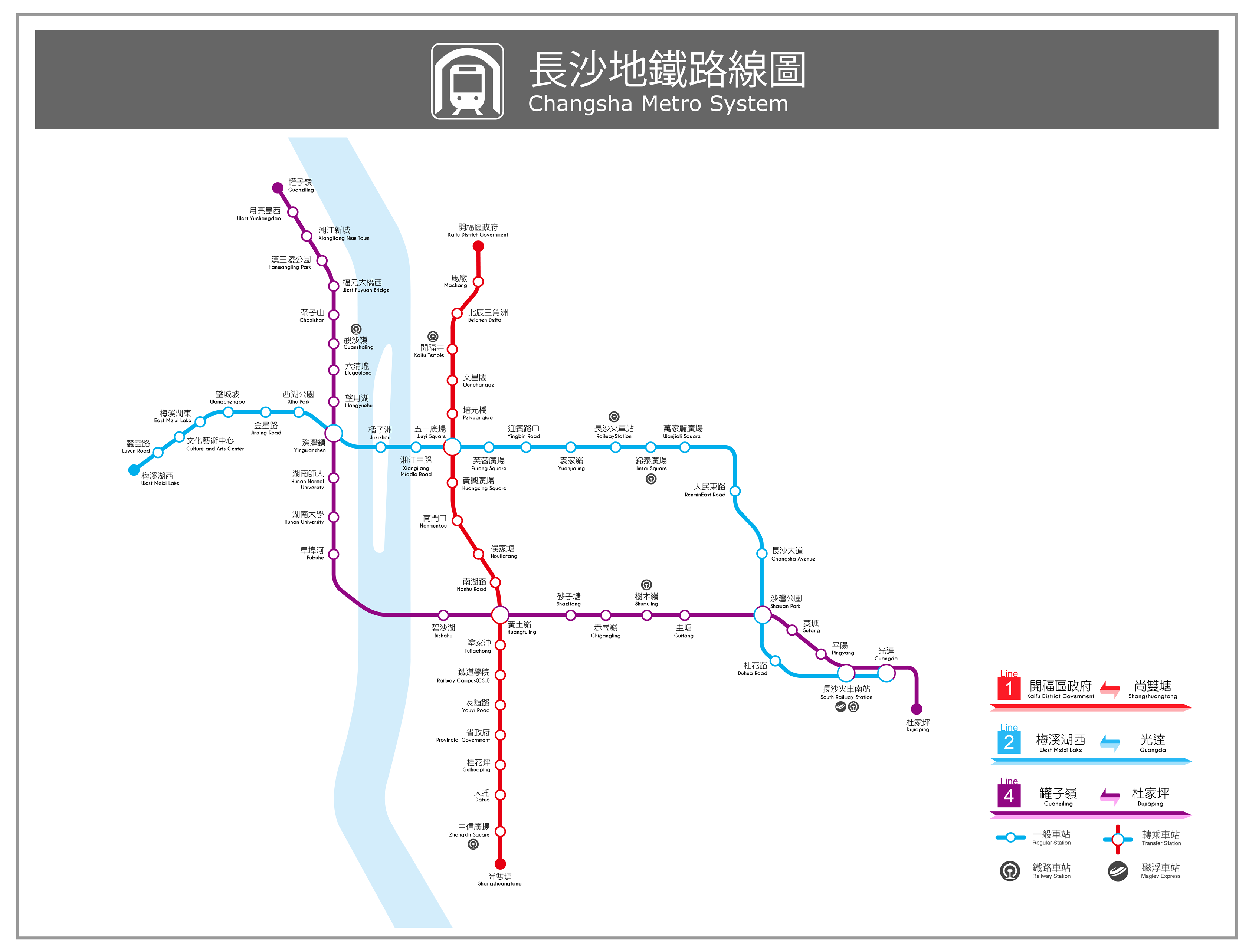
ChangSha Metro Map
Summary
[edit]
| Description |
中文(臺灣):長沙地鐵路線圖 English: ChangSha Metro Map |
| Date | |
| Source | Own work |
| Author | Doraemon.tvb |
Licensing
[edit]
I, the copyright holder of this work, hereby publish it under the following license:
This file is licensed under the Creative Commons Attribution-Share Alike 3.0 Unported license.
- You are free:
- to share – to copy, distribute and transmit the work
- to remix – to adapt the work
- Under the following conditions:
- attribution – You must give appropriate credit, provide a link to the license, and indicate if changes were made. You may do so in any reasonable manner, but not in any way that suggests the licensor endorses you or your use.
- share alike – If you remix, transform, or build upon the material, you must distribute your contributions under the same or compatible license as the original.
File history
Click on a date/time to view the file as it appeared at that time.
| Date/Time | Thumbnail | Dimensions | User | Comment | |
|---|---|---|---|---|---|
| current | 16:40, 26 May 2019 | | 3,374 × 2,566 (585 KB) | Doraemon.tvb (talk | contribs) | updated |
| 02:14, 28 June 2016 |  | 2,917 × 2,639 (561 KB) | Doraemon.tvb (talk | contribs) | updated | |
| 02:06, 7 May 2016 |  | 2,494 × 2,313 (379 KB) | Doraemon.tvb (talk | contribs) | updated | |
| 02:13, 29 December 2015 |  | 2,494 × 2,313 (376 KB) | Doraemon.tvb (talk | contribs) | Update information | |
| 02:03, 7 July 2015 |  | 3,167 × 3,083 (204 KB) | Doraemon.tvb (talk | contribs) | User created page with UploadWizard |
You cannot overwrite this file.
File usage on Commons
The following 15 pages use this file:
- User:Chumwa/OgreBot/Potential transport maps/2016 June 21-30
- User:Chumwa/OgreBot/Potential transport maps/2016 May 1-10
- User:Chumwa/OgreBot/Potential transport maps/2019 May 21-31
- User:Chumwa/OgreBot/Public transport information/2015 December 21-31
- User:Chumwa/OgreBot/Public transport information/2016 June 21-30
- User:Chumwa/OgreBot/Public transport information/2016 May 1-10
- User:Chumwa/OgreBot/Public transport information/2019 May 21-31
- User:Chumwa/OgreBot/Transport Maps/2015 December 21-31
- User:Chumwa/OgreBot/Transport Maps/2016 June 21-30
- User:Chumwa/OgreBot/Transport Maps/2016 May 1-10
- User:Chumwa/OgreBot/Transport Maps/2019 May 21-31
- User:Chumwa/OgreBot/Travel and communication maps/2016 June 21-30
- User:Chumwa/OgreBot/Travel and communication maps/2016 May 1-10
- User:Chumwa/OgreBot/Travel and communication maps/2019 May 21-31
- File:ChangSha Metro Map 2014.png (file redirect)