File:Château de Morthemer Vue Nord.jpg
Jump to navigation
Jump to search

Size of this preview: 800 × 511 pixels. Other resolutions: 320 × 204 pixels | 640 × 409 pixels | 1,024 × 654 pixels | 1,280 × 817 pixels | 2,000 × 1,277 pixels.
Original file (2,000 × 1,277 pixels, file size: 1.46 MB, MIME type: image/jpeg)
Captions
Captions
Add a one-line explanation of what this file represents
Summary
[edit]| Description |
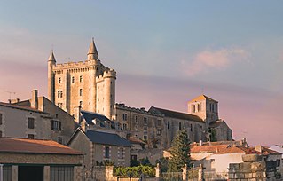
Français : Château de Morthemer Vue Nord et Église Notre-Dame-de-l'Assomption (Morthemer) English: Castle Morthemer North View and Church Notre-Dame-de-l'Assomption (Morthemer) Face exposed
|
|||
| Date | ||||
| Source | Own work | |||
| Author |
| |||
| Attribution (required by the license) | © Emmanuel Dissais / Wikimedia Commons / | |||
| Permission (Reusing this file) |
I, the copyright holder of this work, hereby publish it under the following license: This file is licensed under the Creative Commons Attribution-Share Alike 4.0 International license.
|
|||
| Other versions |
|


| Camera location | | View this and other nearby images on: OpenStreetMap |
|---|

|
This image has been assessed under the valued image criteria and is considered the most valued image on Commons within the scope: Castle of Morthemer first Château de Morthemer Exposed W basically Notre-Dame-de-l'Assomption France. You can see its nomination here. |
File history
Click on a date/time to view the file as it appeared at that time.
| Date/Time | Thumbnail | Dimensions | User | Comment | |
|---|---|---|---|---|---|
| current | 19:04, 4 June 2018 | | 2,000 × 1,277 (1.46 MB) | Emmanuel Dissais (talk | contribs) | User created page with UploadWizard |
You cannot overwrite this file.
File usage on Commons
The following 9 pages use this file:
- User:Emmanuel Dissais
- User:Emmanuel Dissais/galerie
- User talk:Emmanuel Dissais
- Commons:Valued image candidates/Château de Morthemer Vue Nord.jpg
- File:Château de Morthemer Vue Nord.jpg
- File:Donjon du château de morthemer ouest.jpg
- Category:Maps of Valdivienne
- Category:Valdivienne
- Category:Église Notre-Dame-de-l'Assomption Morthemer (Valdivienne)
File usage on other wikis
The following other wikis use this file:
- Usage on ca.wikipedia.org
- Usage on ce.wikipedia.org
- Usage on de.wikipedia.org
- Usage on eo.wikipedia.org
- Usage on es.wikipedia.org
- Usage on eu.wikipedia.org
- Usage on fr.wikipedia.org
- Usage on hu.wikipedia.org
- Usage on it.wikipedia.org
- Usage on oc.wikipedia.org
- Usage on pl.wikipedia.org
- Usage on ro.wikipedia.org
- Usage on tt.wikipedia.org
- Usage on uk.wikipedia.org
- Usage on uz.wikipedia.org
- Usage on vec.wikipedia.org
- Usage on vo.wikipedia.org
- Usage on www.wikidata.org
- Usage on zh.wikipedia.org