File:Chât. H2O, Mazières (79).jpg
Jump to navigation
Jump to search
Size of this preview: 400 × 599 pixels. Other resolutions: 160 × 240 pixels | 320 × 480 pixels | 660 × 988 pixels.
Original file (660 × 988 pixels, file size: 174 KB, MIME type: image/jpeg)
Captions
Captions
Add a one-line explanation of what this file represents
Summary
[edit].jpg&action=edit§ion=1)
| Description |
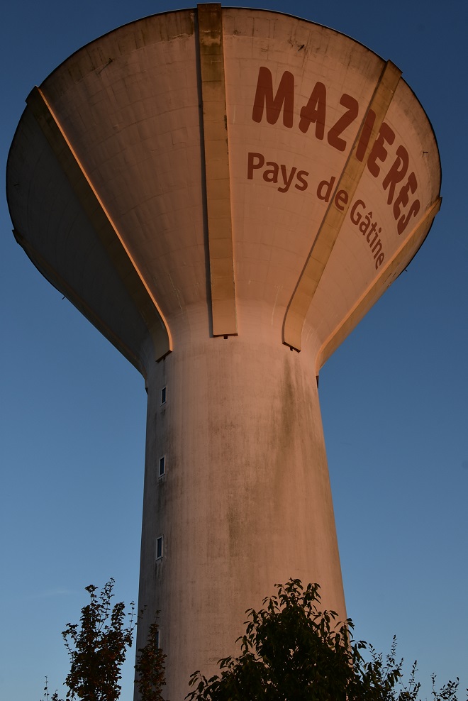
Français : Château d'eau de Mazières en Gâtine (79), vu sous un soleil couchant. La localité possède un autre ouvrage plus près du centre, désaffecté depuis de nombreuses années et en instance de démolition.
Bâti en 1972 à côté de la ligne Niort-Parthenay, l'équipement route de Beaulieu, point de repère incontournable dans le paysage, s'élève à 37 m. Deux cuves, pouvant contenir respectivement 500 et 2 000 m3, se trouvent au sommet. Le SMEG, organisme gestionnaire, l'a totalement rénové à l'été 2019 pour un montant de 500 000 €. Avec un effort axé sur la machinerie, conduites et pompes... sans oublier la déco extérieure ! |
| Date | |
| Source | Own work |
| Author | Dacia 1410 Sport |
| Camera location | | View this and other nearby images on: OpenStreetMap |
|---|
.jpg¶ms=046.543390_N_-000.305170_E_globe:Earth_type:camera_heading:19.00&language=en)
Licensing
[edit].jpg&action=edit§ion=2)
I, the copyright holder of this work, hereby publish it under the following license:
This file is licensed under the Creative Commons Attribution-Share Alike 4.0 International license.
- You are free:
- to share – to copy, distribute and transmit the work
- to remix – to adapt the work
- Under the following conditions:
- attribution – You must give appropriate credit, provide a link to the license, and indicate if changes were made. You may do so in any reasonable manner, but not in any way that suggests the licensor endorses you or your use.
- share alike – If you remix, transform, or build upon the material, you must distribute your contributions under the same or compatible license as the original.
File history
Click on a date/time to view the file as it appeared at that time.
| Date/Time | Thumbnail | Dimensions | User | Comment | |
|---|---|---|---|---|---|
| current | 04:25, 25 October 2023 | | 660 × 988 (174 KB) | Dacia 1410 Sport (talk | contribs) | Uploaded own work with UploadWizard |
You cannot overwrite this file.
File usage on Commons
There are no pages that use this file.
.jpg&oldid=860578405)