File:Cerro do Castelo da Nave.png
Jump to navigation
Jump to search
Size of this preview: 455 × 599 pixels. Other resolutions: 182 × 240 pixels | 497 × 654 pixels.
Original file (497 × 654 pixels, file size: 1.26 MB, MIME type: image/png)
Captions
Captions
Add a one-line explanation of what this file represents
Summary
[edit]
| Description |
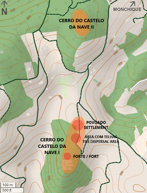
Português: Mapa com as duas áreas arqueológicas do Cerro do Castelo da Nave, no concelho de Monchique, em Portugal. O sítio arqueológico do Cerro do Castelo da Nave I, situado a Sul, corresponde a uma fortificação islâmica com uma área habitacional própria a um nível mais baixo, tendo sido encontrada uma mancha de vestígios entre os dois núcleos, onde foi recolhida uma grande quantidade de telhas. A Norte encontra-se o Cerro do Castelo da Nave II, um povoado fortificado que foi habitado durante as idades do bronze e do ferro e o período romano.
English: Map with the two archaeological areas of Cerro do Castelo da Nave, in the municipality of Monchique, in Portugal. The archaeological site of Cerro do Castelo da Nave I, located to the south, corresponds to an Islamic fortification with its own housing area at a lower level. Between the fort and the settlement is a layer of materials, mostly roof tiles. To the north is the Cerro do Castelo da Nave II, a fortified settlement that was inhabited during the Bronze and Iron Ages and the Roman period. |
|||||||||||||||
| Date | ||||||||||||||||
| Source |
|
|||||||||||||||
| Author | Ajpvalente and OpenStreetMap contributors |
Licensing
[edit]
This file is licensed under the Creative Commons Attribution-Share Alike 2.0 Generic license.
- You are free:
- to share – to copy, distribute and transmit the work
- to remix – to adapt the work
- Under the following conditions:
- attribution – You must give appropriate credit, provide a link to the license, and indicate if changes were made. You may do so in any reasonable manner, but not in any way that suggests the licensor endorses you or your use.
- share alike – If you remix, transform, or build upon the material, you must distribute your contributions under the same or compatible license as the original.
File history
Click on a date/time to view the file as it appeared at that time.
| Date/Time | Thumbnail | Dimensions | User | Comment | |
|---|---|---|---|---|---|
| current | 13:45, 19 October 2022 | | 497 × 654 (1.26 MB) | Ajpvalente (talk | contribs) | Slightly improved the image. |
| 03:03, 19 October 2022 |  | 497 × 654 (264 KB) | Ajpvalente (talk | contribs) | Expanded the map, to include the second site. | |
| 04:56, 17 October 2022 |  | 1,010 × 628 (309 KB) | Ajpvalente (talk | contribs) | Uploaded a work by Ajpvalente and OpenStreetMap contributors from {{OpenStreetMap}} with UploadWizard |
You cannot overwrite this file.
File usage on Commons
The following page uses this file:
File usage on other wikis
The following other wikis use this file:
- Usage on pt.wikipedia.org
- Usage on www.wikidata.org