File:Cerere Topographic Map NASA.jpg
Jump to navigation
Jump to search

Size of this preview: 800 × 400 pixels. Other resolutions: 320 × 160 pixels | 640 × 320 pixels | 1,024 × 512 pixels | 1,610 × 805 pixels.
Original file (1,610 × 805 pixels, file size: 450 KB, MIME type: image/jpeg)
Captions
Captions
Add a one-line explanation of what this file represents
Summary
[edit]
| Description |
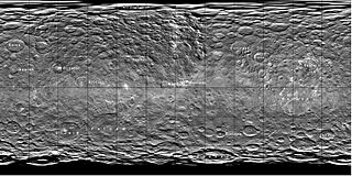
English: Topographic Map of Ceres. Derivative work from original picture with comments from NASA (http://planetarynames.wr.usgs.gov/images/ceres.pdf) Italiano: Mappa topografica di Cerere. Proiezione equirettangolare. Area rappresentata: 90°N-90°S; 180°W-180°E. Immagine ottenuta ritagliando un immagine di pubblico domino creata dalla NASA e disponibile a queso URL: http://planetarynames.wr.usgs.gov/images/ceres.pdf |
| Date | |
| Source | Own work |
| Author | Ysogo |
Licensing
[edit]
I, the copyright holder of this work, hereby publish it under the following license:
This file is licensed under the Creative Commons Attribution-Share Alike 4.0 International license.
- You are free:
- to share – to copy, distribute and transmit the work
- to remix – to adapt the work
- Under the following conditions:
- attribution – You must give appropriate credit, provide a link to the license, and indicate if changes were made. You may do so in any reasonable manner, but not in any way that suggests the licensor endorses you or your use.
- share alike – If you remix, transform, or build upon the material, you must distribute your contributions under the same or compatible license as the original.
File history
Click on a date/time to view the file as it appeared at that time.
| Date/Time | Thumbnail | Dimensions | User | Comment | |
|---|---|---|---|---|---|
| current | 21:43, 28 July 2015 | | 1,610 × 805 (450 KB) | Ysogo (talk | contribs) | User created page with UploadWizard |
You cannot overwrite this file.
File usage on Commons
There are no pages that use this file.
File usage on other wikis
The following other wikis use this file:
- Usage on ca.wikipedia.org
- Abellio (cràter)
- Achita (cràter)
- Annona (cràter)
- Anura (cràter)
- Attis (cràter)
- Axomama (cràter)
- Azacca (cràter)
- Belun (cràter)
- Besua (cràter)
- Bilwis (cràter)
- Binayo (cràter)
- Bonsu (cràter)
- Cachimana (cràter)
- Chaminuka (cràter)
- Cozobi (cràter)
- Kaneki (cràter)
- Dada (cràter)
- Damia (cràter)
- Dantu (cràter)
- Darzamat (cràter)
- Datan (cràter)
- Dikhan (cràter)
- Doliku (cràter)
- Emesh (cràter)
- Enkimdu (cràter)
- Ernutet (cràter)
- Ezinu (cràter)
- Fejokoo (cràter)
- Fluusa (cràter)
- Gaue (cràter)
- Geshtin (cràter)
- Ghanan (cràter)
- Halki (cràter)
- Hamori (cràter)
- Haulani
- Heneb
- Homshuk
- Ikapati
- Inamahari
- Inkosazana
- Insitor
- Jacheongbi
- Jaja (cràter)
- Jarimba
- Jarovit
- Juling
- Jumis
- Kahukura
- Kaikara
- Kait
View more global usage of this file.