File:Century Building, State Street and Adams Street, Chicago, IL (52901593775).jpg
Jump to navigation
Jump to search

Size of this preview: 449 × 599 pixels. Other resolutions: 180 × 240 pixels | 360 × 480 pixels | 576 × 768 pixels | 768 × 1,024 pixels | 1,536 × 2,048 pixels | 2,900 × 3,867 pixels.
Original file (2,900 × 3,867 pixels, file size: 4.01 MB, MIME type: image/jpeg)
Captions
Captions
Add a one-line explanation of what this file represents
Summary
[edit].jpg&action=edit§ion=1)
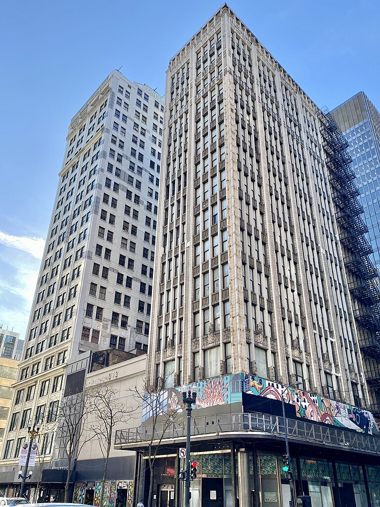
| Description | Built in 1915, this Chicago School-style skyscraper was designed by Holabird and Roche, and is known as the Century Building, and housed commercial office space during the 20th Century. The building stands 16 stories and 185 feet (56 meters) tall, with terra cotta facades along State Street and Adams Street featuring fluted pilasters at the corners and between groups of four window bays, simpler pilaster “ribs” between individual windows, one-over-one windows, Chicago-style windows on the third floor, decorative reliefs on the spandrel panels, with sculptures on the spandrels between the second and third floors, decorative sculptures and fins on the parapet enclosing the building’s low-slope roof, and a modified first floor and second floor facade, which features more modern cladding and storefronts, a mural on the second-story cladding, as well as a sidewalk shed. The building is a contributing structure in the Loop Retail Historic District, listed on the National Register of Historic Places in 1998. The building, along with the entire block, has been vacant since it was seized via eminent domain by the General Services Administration, a branch of the United States federal government, in 2005, recently being threatened with demolition due to alleged but poorly established and inadequately proven supposed “security risks” that seem to be more related to personal and political shenanigans by public officials in a nearby federal building than to any actual threat. Illustrating as to why this bizarre reasoning makes no sense, several federal office buildings exist elsewhere in the United States within similar proximity to other towers or in low-rise buildings adjacent to much taller privately owned structures, and these apparently do not have such issues. |
| Date | |
| Source | Century Building, State Street and Adams Street, Chicago, IL |
| Author | Warren LeMay from Covington, KY, United States |
| Camera location | | View this and other nearby images on: OpenStreetMap |
|---|
.jpg¶ms=041.879544_N_-087.627639_E_globe:Earth_type:camera_source:Flickr_&language=en)
Licensing
[edit].jpg&action=edit§ion=2)
This file is licensed under the Creative Commons Attribution-Share Alike 2.0 Generic license.
- You are free:
- to share – to copy, distribute and transmit the work
- to remix – to adapt the work
- Under the following conditions:
- attribution – You must give appropriate credit, provide a link to the license, and indicate if changes were made. You may do so in any reasonable manner, but not in any way that suggests the licensor endorses you or your use.
- share alike – If you remix, transform, or build upon the material, you must distribute your contributions under the same or compatible license as the original.
| This image was originally posted to Flickr by w_lemay at https://flickr.com/photos/59081381@N03/52901593775. It was reviewed on 6 June 2023 by FlickreviewR 2 and was confirmed to be licensed under the terms of the cc-by-sa-2.0. |
File history
Click on a date/time to view the file as it appeared at that time.
| Date/Time | Thumbnail | Dimensions | User | Comment | |
|---|---|---|---|---|---|
| current | 00:01, 6 June 2023 | | 2,900 × 3,867 (4.01 MB) | SecretName101 (talk | contribs) | Transferred from Flickr via #flickr2commons |
You cannot overwrite this file.
File usage on Commons
There are no pages that use this file.
.jpg&oldid=853176790)