File:Centro de Interpretação Arqueológica do Crasto de Palheiros - Portugal (6085343684).jpg

Original file (7,696 × 5,130 pixels, file size: 15 MB, MIME type: image/jpeg)
Captions
Captions
Summary
[edit].jpg&action=edit§ion=1)
| Description |
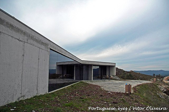
Foi dada uma especial atenção à forma como um visitante acede ao edifício, pois é limitado a apenas uma via pedonal que teve por objectivo observar o relacionamento dos edifícios, com o extraordinário vale do rio Tua. Localizado em Murça, Portugal, o Centro de Interpretação Arqueológica camufla-se na paisagem, proporcionando aos visitantes a recepção necessária. O edifício foi construído como infraestrutura de apoio ao sítio arqueológico de Crasto de Palheiros. É constituída por uma área de recepção, centro de interpretação, espaço para exposições, estacionamento e caminhos para visitar o local com sinalização correspondente. O espaço interior é aberto e fluido, compartimentado apenas quando necessário, para as instalações sanitárias e depósito de água. O espaço abriga uma pequena exposição composta de diferentes materiais e objectos da escavação arqueológica, e tem uma vídeo-instalação onde passar o tempo explicando a recuperação local. in <a href="http://www.skyscrapercity.com/showthread.php?t=1258999" rel="nofollow">www.skyscrapercity.com/showthread.php?t=1258999</a>
Segundo o site do sítio, “entre 2900 e 2300 antes de Cristo, toda a crista, com 2,5 ha, foi transformada num grande monumento pétreo, pré-histórico”. O Centro traz uma cafeteria, centro de informações e algumas peças retiradas das escavações, além de banheiros. Uma característica interessante da arquitetura do prédio é que uma das paredes é a própria rocha da montanha. O sítio arqueológico fica em Murça, Portugal. in <a href="http://www.viajandaunblog.pop.com.br...to-em-portugal" rel="nofollow">www.viajandaunblog.pop.com.br...to-em-portugal</a> <a href="http://www.arquitectura.pt/forum/f10/mur-a-centro-de-interpreta-arqueol-gica-paulo-gomes-15366/" rel="nofollow">www.arquitectura.pt/forum/f10/mur-a-centro-de-interpreta-...</a> <a href="http://loc.alize.us/#/flickr:6085343684" rel="nofollow">See where this picture was taken.</a> <a href="https://www.flickr.com/groups/geotagging/discuss/72157594165549916/">[?]</a> |
| Date | |
| Source | Centro de Interpretação Arqueológica do Crasto de Palheiros - Portugal |
| Author | Vitor Oliveira from Torres Vedras, PORTUGAL |
| Camera location | | View this and other nearby images on: OpenStreetMap |
|---|
.jpg¶ms=041.403952_N_-007.381182_E_globe:Earth_type:camera_source:Flickr_&language=en)
Licensing
[edit].jpg&action=edit§ion=2)
- You are free:
- to share – to copy, distribute and transmit the work
- to remix – to adapt the work
- Under the following conditions:
- attribution – You must give appropriate credit, provide a link to the license, and indicate if changes were made. You may do so in any reasonable manner, but not in any way that suggests the licensor endorses you or your use.
- share alike – If you remix, transform, or build upon the material, you must distribute your contributions under the same or compatible license as the original.
| This image was originally posted to Flickr by Portuguese_eyes at https://flickr.com/photos/21446942@N00/6085343684 (archive). It was reviewed on 15 April 2019 by FlickreviewR 2 and was confirmed to be licensed under the terms of the cc-by-sa-2.0. |
File history
Click on a date/time to view the file as it appeared at that time.
| Date/Time | Thumbnail | Dimensions | User | Comment | |
|---|---|---|---|---|---|
| current | 05:05, 15 April 2019 | | 7,696 × 5,130 (15 MB) | Tm (talk | contribs) | Transferred from Flickr via #flickr2commons |
You cannot overwrite this file.
File usage on Commons
There are no pages that use this file.
.jpg&oldid=885933205)