File:Central Haifa.png
Jump to navigation
Jump to search
Size of this preview: 644 × 600 pixels. Other resolutions: 258 × 240 pixels | 516 × 480 pixels | 825 × 768 pixels | 1,100 × 1,024 pixels | 2,199 × 2,048 pixels | 4,110 × 3,827 pixels.
Original file (4,110 × 3,827 pixels, file size: 2.67 MB, MIME type: image/png)
Captions
Captions
Add a one-line explanation of what this file represents
Summary
[edit]
| Description |
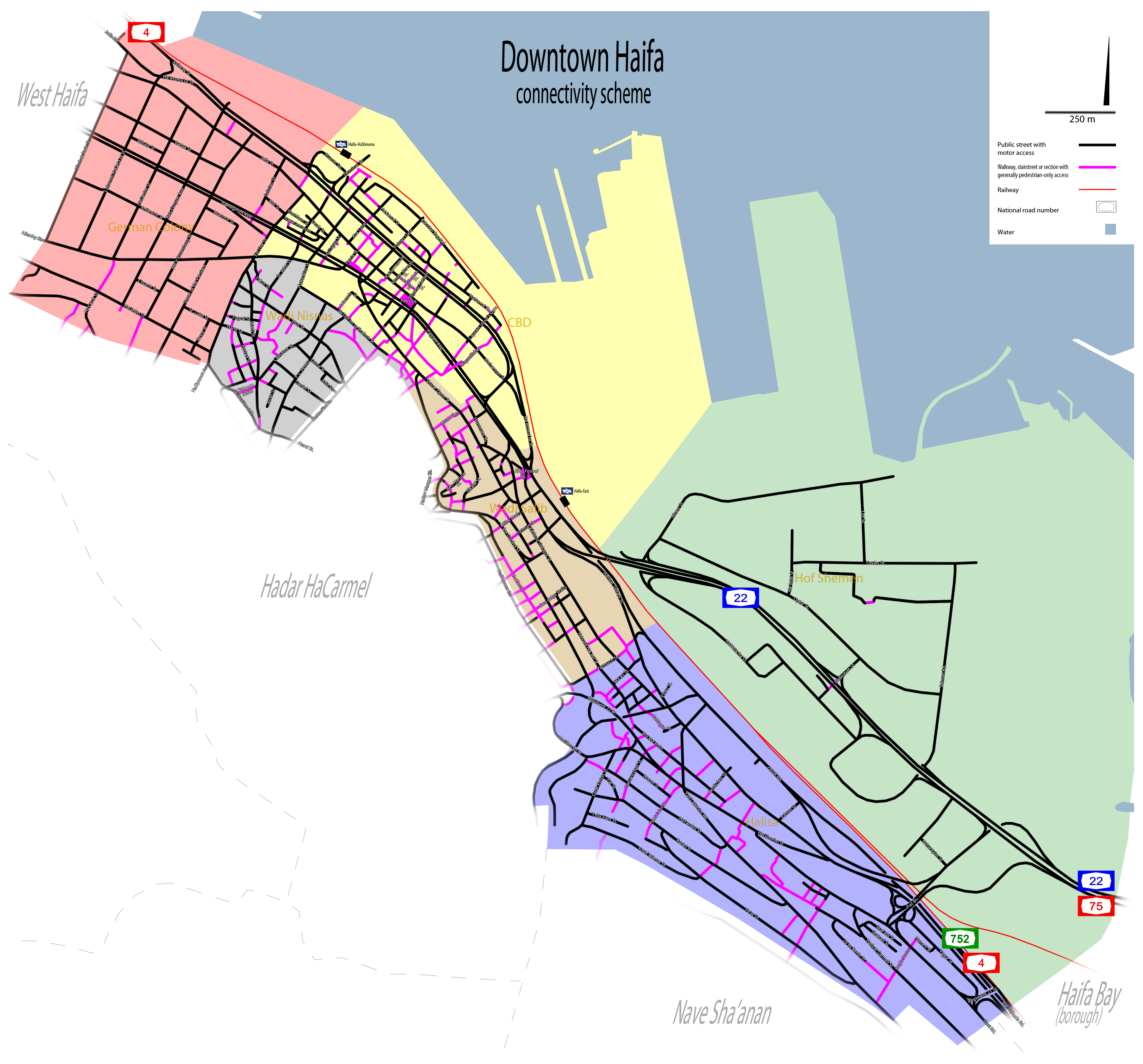
English: Zone-mapping of public routes existing as of 2012, portraying the complete streetweb incorporating unofficial through-ways side by side with to-scale proportion demonstration of uncivilized area (industry and port reservations) compared with the urban strip where the more streets are found. As it does not include gated ranges and/or watchman-operated passageways and focuses exclusively on casually-accessed foot traffic channels, with only few proposed reparations – this reflective map examines an existing ‘wander’ consecutivenesses of a given time, as a possible study case of challenged town-cores in medium-sized cites, when applying only the criterion of human’s access. The six sub-zones of downtown Haifa appear in different colours and illustrate different planning behaviours responding to the neighbourhoods’ each social and geographic patterns. It is notable and fascinating that many of the north–south orienting ways (in purple) are staircases, that were never planned or listed but were - and are - used throughout generations to compensate for the lack of direct north-south paved links, secondary to the terraced structure of the terrain, expressed in this whole borough in itself being a long and narrow east-westbound belt with somewhat little spatial depth. Intimate and informal, these stairways give the tone and character to a vast share of Haifa’s streetview and suggest one of its most firmly-identifiable and perceptible dimensions. It is worth noting that the only really flat area in the entire city is that captured by the infrastructures associated with the industry and port along the bay shore, part of which having been dried in various periods to allow the expansion of this land use. In its superficiality and clarity, the map may thus give an idea of reading the given old tissue through a universal variable and provoke a notion on the immense assemblage of civic opportunities in central Haifa. עברית: מרכז חיפה. |
| Date | |
| Source | Own work |
| Author | Orrling |
| Permission (Reusing this file) |
Please attribute to me with appropriate crediting whenever using the image outside Wikipedia. Thanks, Orrling |
Licensing
[edit]
I, the copyright holder of this work, hereby publish it under the following license:
This file is licensed under the Creative Commons Attribution-Share Alike 3.0 Unported license.
- You are free:
- to share – to copy, distribute and transmit the work
- to remix – to adapt the work
- Under the following conditions:
- attribution – You must give appropriate credit, provide a link to the license, and indicate if changes were made. You may do so in any reasonable manner, but not in any way that suggests the licensor endorses you or your use.
- share alike – If you remix, transform, or build upon the material, you must distribute your contributions under the same or compatible license as the original.
File history
Click on a date/time to view the file as it appeared at that time.
| Date/Time | Thumbnail | Dimensions | User | Comment | |
|---|---|---|---|---|---|
| current | 05:43, 20 October 2013 | | 4,110 × 3,827 (2.67 MB) | Orrling (talk | contribs) | Missed one walkway |
| 04:03, 20 October 2013 |  | 4,110 × 3,827 (2.67 MB) | Orrling (talk | contribs) | Wrong file | |
| 03:56, 20 October 2013 |  | 4,110 × 3,827 (2.63 MB) | Orrling (talk | contribs) | User created page with UploadWizard |
You cannot overwrite this file.
File usage on Commons
There are no pages that use this file.