File:Celtic field system near Arncliffe Cote Simmons 1971 Page055.jpg
Jump to navigation
Jump to search

Size of this preview: 753 × 600 pixels. Other resolutions: 302 × 240 pixels | 603 × 480 pixels | 965 × 768 pixels | 1,280 × 1,019 pixels | 1,776 × 1,414 pixels.
Original file (1,776 × 1,414 pixels, file size: 574 KB, MIME type: image/jpeg)
Captions
Captions
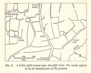
Celtic field system near Arncliffe Cote
Summary
[edit]
| Description |
English: Celtic field system near Arncliffe Cote. Figure 6 from: Yorkshire Dales National Park Guide |
| Date | |
| Source | https://archive.org/details/yorkshire-dales-national-park |
| Author | Simmons, I.G. (Ian Gordon) 1937- |
| Object location | | View this and other nearby images on: OpenStreetMap |
|---|
Licensing
[edit]
This work created by the United Kingdom Government is in the public domain.
This is because it is one of the following:
HMSO has declared that the expiry of Crown Copyrights applies worldwide (ref: HMSO Email Reply)
|
 |
File history
Click on a date/time to view the file as it appeared at that time.
| Date/Time | Thumbnail | Dimensions | User | Comment | |
|---|---|---|---|---|---|
| current | 13:50, 7 January 2022 | | 1,776 × 1,414 (574 KB) | Kognos (talk | contribs) | Uploaded a work by Simmons, I.G. (Ian Gordon) 1937- from https://archive.org/details/yorkshire-dales-national-park with UploadWizard |
You cannot overwrite this file.
File usage on Commons
There are no pages that use this file.