File:Caucasus 80 BC map de.svg
Jump to navigation
Jump to search

Size of this PNG preview of this SVG file: 771 × 599 pixels. Other resolutions: 309 × 240 pixels | 618 × 480 pixels | 988 × 768 pixels | 1,280 × 995 pixels | 2,560 × 1,990 pixels | 1,155 × 898 pixels.
Original file (SVG file, nominally 1,155 × 898 pixels, file size: 4.42 MB)
Captions
Captions
Add a one-line explanation of what this file represents
Summary
[edit]| Description |
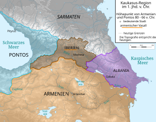
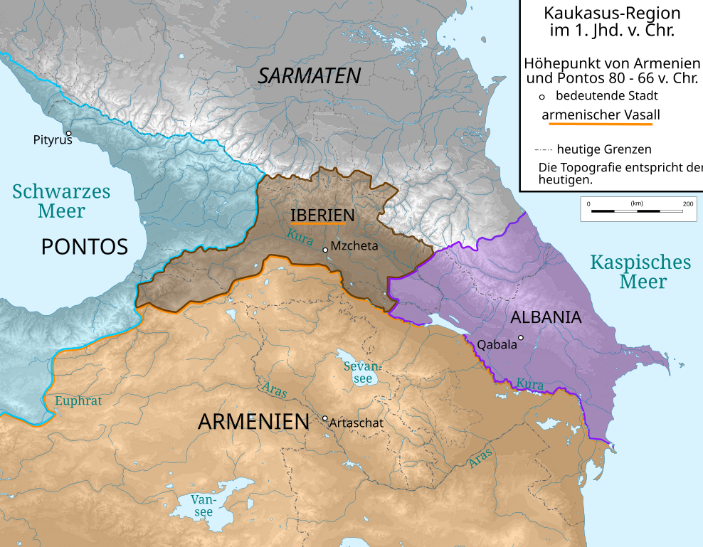
Deutsch: Kaukasus-Region um 80 v. Chr. Quellen sind File:Geor_earliest_2A.jpg , Putzger historischer Weltatlas Ausgabe 2005, http://www.armenica.org/cgi-bin/armenica.cgi?178711717323498=1=3==Armenia==1=3=AAA , Heinz Fähnrich: Geschichte Georgiens von den Anfängen bis zur Mongolenherrschaft. Shaker, Aachen 1993, ISBN 3-86111-683-9. |
| Date | |
| Source | work by uploader, derivate of File:Caucasus_topographic_map-fr.svg and File:Artaxiad Armenia 80BC-fr.svg |
| Author | Don-kun, Bourrichon - fr:Bourrichon |
| Other versions |
|

This W3C-unspecified vector image was created with Inkscape .
Licensing
[edit]
I, the copyright holder of this work, hereby publish it under the following licenses:
This file is licensed under the Creative Commons Attribution-Share Alike 3.0 Unported license.
- You are free:
- to share – to copy, distribute and transmit the work
- to remix – to adapt the work
- Under the following conditions:
- attribution – You must give appropriate credit, provide a link to the license, and indicate if changes were made. You may do so in any reasonable manner, but not in any way that suggests the licensor endorses you or your use.
- share alike – If you remix, transform, or build upon the material, you must distribute your contributions under the same or compatible license as the original.

|
Permission is granted to copy, distribute and/or modify this document under the terms of the GNU Free Documentation License, Version 1.2 or any later version published by the Free Software Foundation; with no Invariant Sections, no Front-Cover Texts, and no Back-Cover Texts. A copy of the license is included in the section entitled GNU Free Documentation License. |
You may select the license of your choice.
File history
Click on a date/time to view the file as it appeared at that time.
| Date/Time | Thumbnail | Dimensions | User | Comment | |
|---|---|---|---|---|---|
| current | 05:59, 19 February 2020 | | 1,155 × 898 (4.42 MB) | Don-kun (talk | contribs) | Reverted to version as of 18:18, 23 August 2009 (UTC), change was nonsensical destruction of the map |
| 18:34, 18 February 2020 |  | 1,155 × 898 (4.39 MB) | Takhirgeran Umar (talk | contribs) | об | |
| 18:18, 23 August 2009 |  | 1,155 × 898 (4.42 MB) | Don-kun (talk | contribs) | cor, former source was Armenian Foreign Ministry, now armenica.org and Fähnrich | |
| 11:13, 8 August 2009 |  | 1,155 × 898 (4.41 MB) | Don-kun (talk | contribs) | new version | |
| 16:15, 1 April 2009 |  | 1,155 × 898 (4.46 MB) | Don-kun (talk | contribs) | {{Information |Description={{de|1=Kaukasus-Region um 300 n. Chr. Quellen sind http://commons.wikimedia.org/wiki/File:Geor_earliest_2A.jpg , File:Artaxiad Armenia 80BC-fr.svg , Putzger historischer Weltatlas Ausgabe 2005, Heinz Fähnrich: ''Geschichte Ge |
You cannot overwrite this file.
File usage on Commons
The following 4 pages use this file:
File usage on other wikis
The following other wikis use this file:
- Usage on pt.wikipedia.org
Metadata
Categories:
- SVG maps of the history of Georgia
- SVG maps of the history of Armenia
- SVG maps of the history of Azerbaijan
- Maps of the history of the Caucasus in antiquity
- Maps of the history of Abkhazia
- Maps of the history of the south Caucasus region
- Maps of Caucasian Albania
- Maps of the Kingdom of Iberia
- Derivative maps of Putzgers Historischer Schul-Atlas