File:Castres, Tarn, France.jpg
Original file (3,181 × 3,181 pixels, file size: 7.5 MB, MIME type: image/jpeg)
Captions
Captions
Summary
[edit]
| Description |
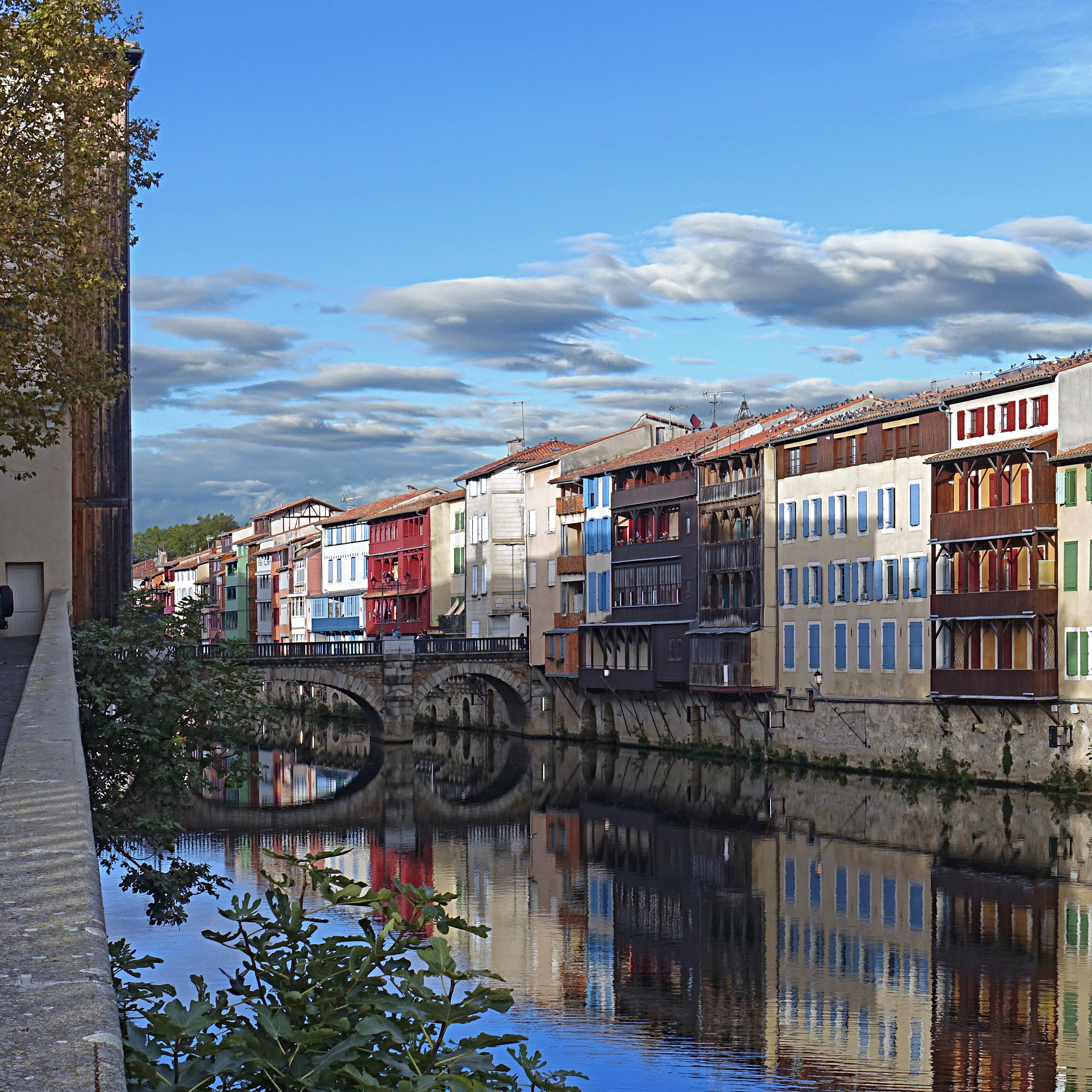
English: Maisons sur l'Agoût, « la petite Venise » du Languedoc
La rivière était autrefois le centre vital de la ville. Ces maisons ont été dès le Moyen Âge le lieu d'activité principal des habitants. Ces maisons d'artisans abritaient différents corps de métiers tels que tanneurs, teinturiers, parcheminiers, papetiers et tisserands. Toutes ces maisons ont des bases médiévales dont les ouvertures sont en berceau ou en ogive. Les caves appelées «caoussino» en occitan (littéralement cela signifie usine à chaux) ouvrent sur la rivière et possédaient des lavoirs. Après avoir nettoyé et rincé les peaux dans l'Agout, on les déposait dans les cuves emplies de chaux. Au rez-de-chaussée étaient situés les appartements des ouvriers puis ceux des maîtres. fr.wikipedia.org/wiki/Castres#Maisons_sur_l'Ago%C3%BBt Houses on the Agout, “Little Venice” of Castres The river was once the vital centre of the city. These houses were since the Middle Ages the main place of activity of the inhabitants. These craftsmen’s houses housed various trades such as tanners, dyers, parchment, paper makers and weavers. All these houses have medieval bases whose openings are in cradle or ogive. The cellars called «caoussino» in Occitan (literally it means lime factory) open onto the river and had wash houses. After cleaning and rinsing the skins in the Agout, they were deposited in the tanks filled with lime. On the ground floor were located the apartments of the workers and those of the masters. Castres, sous-préfecture du Tarn fr.wikipedia.org/wiki/Castres fr.wikipedia.org/wiki/Castres L'Agout (ou Agoût) est un important affluent gauche du Tarn (194 km), donc un sous-affluent de la Garonne. fr.wikipedia.org/wiki/Agout en.wikipedia.org/wiki/Agout |
| Date | |
| Source | https://www.flickr.com/photos/pom-angers/53290379142/ |
| Author | Pom' |
| Camera location | | View this and other nearby images on: OpenStreetMap |
|---|
Licensing
[edit]
- You are free:
- to share – to copy, distribute and transmit the work
- to remix – to adapt the work
- Under the following conditions:
- attribution – You must give appropriate credit, provide a link to the license, and indicate if changes were made. You may do so in any reasonable manner, but not in any way that suggests the licensor endorses you or your use.
- share alike – If you remix, transform, or build upon the material, you must distribute your contributions under the same or compatible license as the original.
| This image was originally posted to Flickr by pom'. at https://flickr.com/photos/146832554@N06/53290379142. It was reviewed on 8 February 2024 by FlickreviewR 2 and was confirmed to be licensed under the terms of the cc-by-sa-2.0. |
File history
Click on a date/time to view the file as it appeared at that time.
| Date/Time | Thumbnail | Dimensions | User | Comment | |
|---|---|---|---|---|---|
| current | 19:26, 8 February 2024 | | 3,181 × 3,181 (7.5 MB) | Durziil89 (talk | contribs) | Uploaded a work by Pom' from https://www.flickr.com/photos/pom-angers/53290379142/ with UploadWizard |
You cannot overwrite this file.
File usage on Commons
There are no pages that use this file.