File:Cast Iron Pillar, Sidehean Mor - geograph.org.uk - 232615.jpg
Jump to navigation
Jump to search
No higher resolution available.
Cast_Iron_Pillar,_Sidehean_Mor_-_geograph.org.uk_-_232615.jpg (640 × 384 pixels, file size: 56 KB, MIME type: image/jpeg)
Captions
Captions
Add a one-line explanation of what this file represents
Summary
[edit]
| Description |
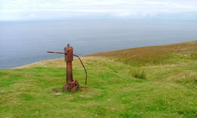
English: Cast Iron Pillar, Sidehean Mor. About ten metres away from 232608 and possibly associated with the nearby WW2 radr station. The pillar has a cast iron upper part which swivels and reminds me of a post for one of those telescopes that are seen on seaside promenades. (The iron bar has been inserted through an hole to lever the turning.) |
| Date | |
| Source | From geograph.org.uk |
| Author | Mick Garratt |
| Attribution (required by the license) | Mick Garratt / Cast Iron Pillar, Sidehean Mor / |
| Camera location | | View this and other nearby images on: OpenStreetMap |
|---|
_heading:0.00&language=en)
| Object location | | View this and other nearby images on: OpenStreetMap |
|---|
_heading:0.00&language=en)
Licensing
[edit]

|
This image was taken from the Geograph project collection. See this photograph's page on the Geograph website for the photographer's contact details. The copyright on this image is owned by Mick Garratt and is licensed for reuse under the Creative Commons Attribution-ShareAlike 2.0 license.
|
This file is licensed under the Creative Commons Attribution-Share Alike 2.0 Generic license.
Attribution: Mick Garratt
- You are free:
- to share – to copy, distribute and transmit the work
- to remix – to adapt the work
- Under the following conditions:
- attribution – You must give appropriate credit, provide a link to the license, and indicate if changes were made. You may do so in any reasonable manner, but not in any way that suggests the licensor endorses you or your use.
- share alike – If you remix, transform, or build upon the material, you must distribute your contributions under the same or compatible license as the original.
- Remove redundant categories and try to put this image in the most specific category/categories
- Remove this template
- The location categories are based on information from this geonames tool and this OpenStreetMap tool combined with a database. You can also have a look at this tool from mysociety.
- The topic category from Geograph was Ruin (find similar images at Geograph)
File history
Click on a date/time to view the file as it appeared at that time.
| Date/Time | Thumbnail | Dimensions | User | Comment | |
|---|---|---|---|---|---|
| current | 22:59, 31 January 2010 | | 640 × 384 (56 KB) | GeographBot (talk | contribs) | == {{int:filedesc}} == {{Information |description={{en|1=Cast Iron Pillar, Sidehean Mor. About ten metres away from [232608] and possibly associated with the nearby WW2 radr station. The pillar has a cast iron upper part which swivels and reminds me o |
You cannot overwrite this file.
File usage on Commons
There are no pages that use this file.