File:Cascade Range geology detail.gif
Jump to navigation
Jump to search

Size of this preview: 602 × 599 pixels. Other resolutions: 241 × 240 pixels | 482 × 480 pixels | 832 × 828 pixels.
Original file (832 × 828 pixels, file size: 144 KB, MIME type: image/gif, 0.1 s)
Captions
Captions
Add a one-line explanation of what this file represents
Summary
[edit]
| Description |
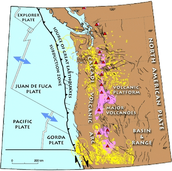
English: Detailed geological map of the Cascade Range and environs. Yellow rings indicate recorded earthquakes. Black lines show faults active within past 10,000 years. |
| Date | (UTC) |
| Source |
This file was derived from: Cascade Range geology detail.png:  |
| Author |
|
Licensing
[edit]
This image is in the public domain in the United States because it only contains materials that originally came from the United States Geological Survey, an agency of the United States Department of the Interior. For more information, see the official USGS copyright policy.
|
AI upscaling:
| This file is made available under the Creative Commons CC0 1.0 Universal Public Domain Dedication. | |
| The person who associated a work with this deed has dedicated the work to the public domain by waiving all of their rights to the work worldwide under copyright law, including all related and neighboring rights, to the extent allowed by law. You can copy, modify, distribute and perform the work, even for commercial purposes, all without asking permission.
|
Original upload log
[edit]
This image is a derivative work of the following images:
- File:Cascade Range geology detail.png licensed with PD-USGov-USGS
- 2013-05-12T18:17:15Z Hike395 416x414 (32768 Bytes) {{Information |Description ={{en|1=Detailed geological map of the Cascade Range and environs. Yellow rings indicate recorded earthquakes. Black lines show faults active within past 10,000 years.}} |Source =http://g
Uploaded with derivativeFX
File history
Click on a date/time to view the file as it appeared at that time.
| Date/Time | Thumbnail | Dimensions | User | Comment | |
|---|---|---|---|---|---|
| current | 22:24, 20 September 2023 | | 832 × 828 (144 KB) | Hike395 (talk | contribs) | == {{int:filedesc}} == {{Information |Description={{en|1=Detailed geological map of the Cascade Range and environs. Yellow rings indicate recorded earthquakes. Black lines show faults active within past 10,000 years.}} |Source={{Derived from|Cascade Range geology detail.png|display=50}} |Date=2023-09-20 22:22 (UTC) |Author=* File:Cascade Range geology detail.png: USGS * AI upscaling: [[User:{{subst:REVISIONUSER}}|{{subst:REVISIONUSER}}]] |Permission=... |
You cannot overwrite this file.
File usage on Commons
The following 2 pages use this file:
File usage on other wikis
The following other wikis use this file:
- Usage on en.wikipedia.org