File:Casa da Câmara - Casal do Meio - Portugal (3092329227).jpg

Original file (1,280 × 960 pixels, file size: 362 KB, MIME type: image/jpeg)
Captions
Captions
Summary
[edit].jpg&action=edit§ion=1)
| Description |
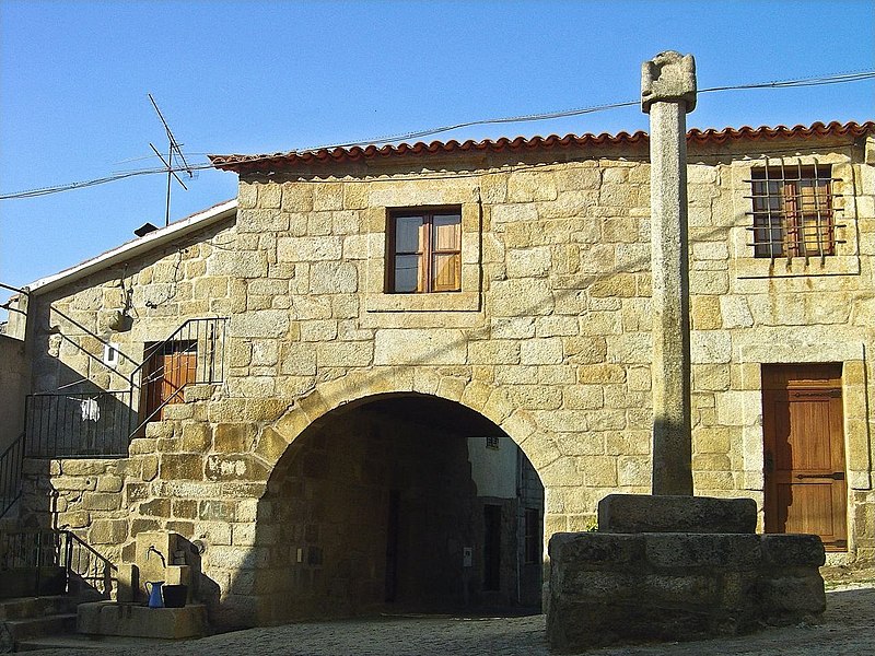
Casal do Meio foi a sede do antigo concelho de Rio de Moinhos, do qual não se conhece foral, tendo sido extinto em 1836, e integrado em Sátão. Rio de Moinhos é freguesia, e Casal do Meio figura hoje como pequeno lugar. Da sua anterior categoria conserva ainda alguns vestígios, como o edifício das velhas cadeia e Casa da Câmara , junto da qual se ergue o pelourinho. Este é muito singelo e de factura bastante rude, acentuada pelo uso do granito, não permitindo datação rigorosa. Será, ainda assim, uma peça enquadrável no conjunto dos mais toscos pelourinhos Quinhentistas. O pelourinho de Casal do Meio levanta-se sobre um soco de dois degraus quadrangulares de aresta, muito desconjuntados, acrescentados de um terceiro, mais baixo, com orifício de encaixe para a coluna, e que funciona como base desta. A coluna arranca com secção quadrada, semelhante ao orifício onde se encaixa, e segue com fuste oitavado, através de chanfro aplicado nas arestas. Eleva-se a cerca de quatro metros de altura. Não tem capitel, sendo directamente encimada pelo remate. Este consta de um bloco aproximadamente cúbico, com vaga forma de castelo, que lhe é dada por pequenos cilindros cantonais talhados no mesmo corpo, ao modo de incipientes colunelos ou torrinhas. Termina em calote semi-esférica. SML <a href="http://www.ippar.pt/pls/dippar/pat_pesq_detalhe?code_pass=72874">www.ippar.pt/pls/dippar/pat_pesq_detalhe?code_pass=72874</a> <a href="http://loc.alize.us/#/flickr:3092329227">See where this picture was taken.</a> <a href="https://www.flickr.com/groups/geotagging/discuss/72157594165549916/">[?]</a> |
| Date | |
| Source | Casa da Câmara - Casal do Meio - Portugal |
| Author | Vitor Oliveira from Torres Vedras, PORTUGAL |
| Camera location | | View this and other nearby images on: OpenStreetMap |
|---|
.jpg¶ms=040.706567_N_-007.705026_E_globe:Earth_type:camera_source:Flickr_&language=en)
Licensing
[edit].jpg&action=edit§ion=2)
- You are free:
- to share – to copy, distribute and transmit the work
- to remix – to adapt the work
- Under the following conditions:
- attribution – You must give appropriate credit, provide a link to the license, and indicate if changes were made. You may do so in any reasonable manner, but not in any way that suggests the licensor endorses you or your use.
- share alike – If you remix, transform, or build upon the material, you must distribute your contributions under the same or compatible license as the original.
| This image was originally posted to Flickr by Portuguese_eyes at https://flickr.com/photos/21446942@N00/3092329227 (archive). It was reviewed on 8 May 2019 by FlickreviewR 2 and was confirmed to be licensed under the terms of the cc-by-sa-2.0. |
File history
Click on a date/time to view the file as it appeared at that time.
| Date/Time | Thumbnail | Dimensions | User | Comment | |
|---|---|---|---|---|---|
| current | 23:22, 12 September 2021 | | 1,280 × 960 (362 KB) | Tm (talk | contribs) | Cropped 2 % horizontally, 3 % vertically using CropTool with precise mode. |
| 02:04, 8 May 2019 |  | 1,310 × 990 (385 KB) | Tm (talk | contribs) | Transferred from Flickr via #flickr2commons |
You cannot overwrite this file.
File usage on Commons
The following page uses this file:
File usage on other wikis
The following other wikis use this file:
- Usage on eo.wikipedia.org
- Usage on es.wikipedia.org
- Usage on pt.wikipedia.org
- Usage on www.wikidata.org
.jpg&oldid=849553399)