File:Cartouche in an Australia map by Bowen.jpg
Original file (1,212 × 589 pixels, file size: 434 KB, MIME type: image/jpeg)
Captions
Summary
[edit]DescriptionCartouche in an Australia map by Bowen.jpg |
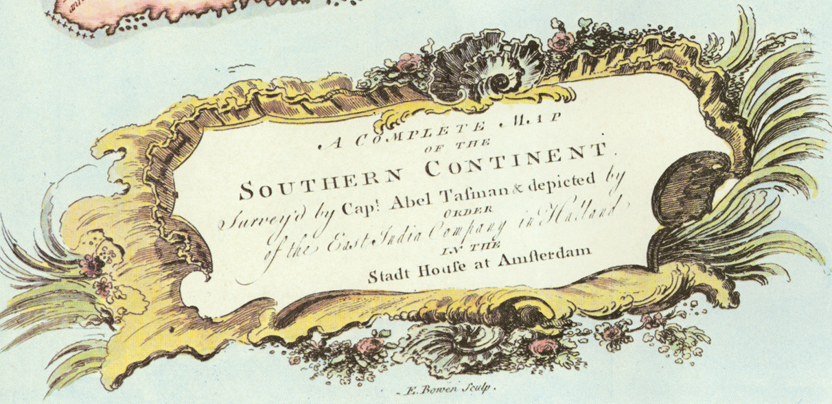
English: A Complete Map of the Southern Continent Survey'd by Capt. Abel Tasman & Depicted by Order of the East India Company in Holland in the Stadt House at Amsterdam (E. Bowen, Sculpt.), one of the Emanuel Bowen maps added to the 1744 2nd edition of John Harris's 1705 Navigantium atque Itinerantium Bibliotheca, or, A Complete Collection of Voyages and Travels, a translation and reprint of Melchisédech Thévenot's 1664 map. |
|||
Date | ||||
Source | National Library of Australia | |||
Author | Emanuel Bowen | |||
Permission (Reusing this file) |
|
|||
Other versions |
|
Licensing
[edit]
This is a faithful photographic reproduction of a two-dimensional, public domain work of art. The work of art itself is in the public domain for the following reason:
The official position taken by the Wikimedia Foundation is that "faithful reproductions of two-dimensional public domain works of art are public domain".
This photographic reproduction is therefore also considered to be in the public domain in the United States. In other jurisdictions, re-use of this content may be restricted; see Reuse of PD-Art photographs for details. |
Original upload log
[edit]Date/Time | Dimensions | User | Comment |
---|---|---|---|
2011-12-04 23:02 | 3000×2323× (2035159 bytes) | Camira | ''A Complete map of the Southern Continent survey'd by Capt. Abel Tasman & depicted by order of the East India Company in Holland in the Stadt House at Amsterdam''; E. Bowen, Sculp. [http://nla.gov.au/nla.gen-an6520463-1-1-1-s324a] |
Annotations InfoField | This image is annotated: View the annotations at Commons |
Equinoctial Line [i.e., the Equator]
[135° E., which (following Thévenot) is treated as a division between New Holland and a separate, mostly unclaimed Terra Australis]
OF THE
SOUTHERN CONTINENT
Survey'd by Capt. Abel Tasman & depicted by
ORDER
of the East India Company in Holland
IN THE
Stadt House at Amsterdam
HOLLANDIA
NOVA
Discovered 1644. [sic]
TROPIC OF CAPRICORN
TERRA AUSTRALIS
Discovered A.D. 1644 [sic]
Vol: I: Page 325.
Van Diemans Land
Discovred 24 Novr. 1642
Landt van de Leuwin
anno 1622 aangeds an
Land of Peter Nuyts Discovered 16. Jany. 1627.
NB. This is the Country seated according to Coll: Purry in the best Climate in the World.
I. de Edelslandt
beseigilt Anno 1619
G.F. de Witlandt
detecta 1628.
CARPENTARIA
TERRA DOS PAPOS
by the Spaniards
NEW GUINEA
by Jacob le Maire
Land first seen
ZEELANDIA NOVA
This Map is very exactly Copied from the Original and therefore the Dutch Names have been preserved that if hereafter any Discoveries should ever be Attempted all the places mentioned may be readily found in the Dutch Charts which must be procured for such a Voyage. The Reader is desired to observe that nothing is marked here but what has been Actually discovered which is the reason of the white Space between New Holland and New Zealand, and again between New Zeland and New Guinea which make the South and East sides of Terra Australis; It is also requisite to observe that the Country discovered by Ferdinand de Quiros lies according to his description on the East Side of this Continent directly Opposite to Carpentaria which if Attentively considered will add no small weight to the Credit of what he has written about that Country and which has been very rashly as well as very unjustly treated by some Critical Writers as a Fiction; whereas it Appears from this Map of Actual Discoveries, that there is a Country where Ferdinand de Quiros says he found one: And if so why may not that Country be such a one as he discribes? In Tasman Voyage we have shewn why he did not make this Matter more plain.
It is impossible to conceive a Country that promises fairer from its Situation than this of Terra Australis; no longer incognita, as this Map demonstrates, but the Southern Continent Discovered. It lies Precisely in the richest Climates of the World. If the Islands of Sumatra, Java, & Borneo, abound in Precious Stones and other valuable Commodities; and the Moluccas in Spices; New Guinea and the Regions behind it must by a parity of Reason be as plentifully endowed by Nature. If the Island of Madagascar is so Noble and plentiful a Country as all Authors speak it; and Gold, Ivory, and other Commodities are common in the Southern part of Africa, from Melinda down to the Cape of Good Hope, and so up again to C. Gonsalez; here are ye same Latitudes in Carpentaria, New Holland, and New Zealand; If Peru overflows with Silver, if all the Mountains of Chili are filled with Gold, and this precious Metal & Stones much more precious are ye product of Brazil; this Continent enjoys the benefit of the same position and therefore whoever perfectly discovers & settles it will become infalliably possessed of Territories as Rich, as fruitful, & as capable of Improvement, as any that have been hitherto found out, either in the East Indies, or in the West.
File history
Click on a date/time to view the file as it appeared at that time.
Date/Time | Thumbnail | Dimensions | User | Comment | |
---|---|---|---|---|---|
current | 17:16, 8 October 2023 | 1,212 × 589 (434 KB) | Enyavar (talk | contribs) | File:Bowen- A Complete map of the Southern Continent.jpg cropped 60 % horizontally, 75 % vertically using CropTool with precise mode. |
You cannot overwrite this file.
File usage on Commons
The following page uses this file: