File:Cartogram-2008 Electoral Vote.gif
Jump to navigation
Jump to search
Size of this preview: 705 × 599 pixels. Other resolutions: 282 × 240 pixels | 565 × 480 pixels | 1,000 × 850 pixels.
Original file (1,000 × 850 pixels, file size: 49 KB, MIME type: image/gif)
Captions
Captions
Add a one-line explanation of what this file represents

|
This election map image could be re-created using vector graphics as an SVG file. This has several advantages; see Commons:Media for cleanup for more information. If an SVG form of this image is available, please upload it and afterwards replace this template with
{{vector version available|new image name}}.
It is recommended to name the SVG file “Cartogram-2008 Electoral Vote.svg”—then the template Vector version available (or Vva) does not need the new image name parameter. |
Summary
[edit]
| Description |
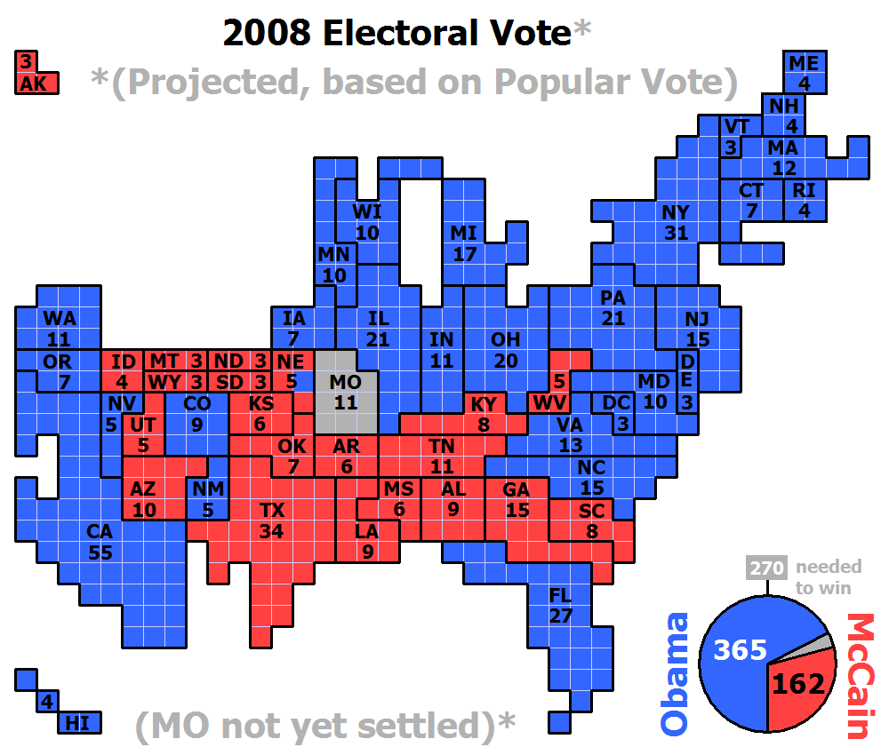
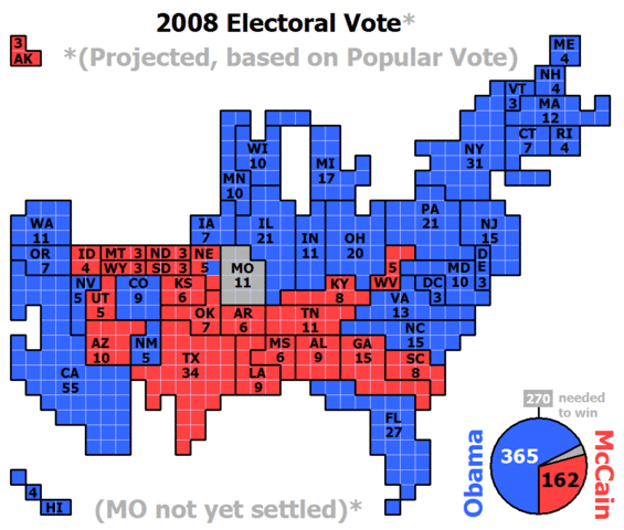
English: Cartogram of the projected 2008 Electoral Vote for US President (based on popular vote) with each square representing one electoral vote. Nebraska, being one of two states that are not winner-take-all, for the first time had its votes split, with NE-2 projected for Obama and the rest of the state for McCain. The population density of the 50 states varies by three orders of magnitude (from NJ with nearly 1,200 people per square mile, to AK with roughly 1 1/4 people per sq mi). Because of that huge variation, a regular map of the US that is typically used to present electoral vote results can convey a very skewed impression of the outcome where sparsely populated states appear overrepresented and densely populated states appear underrepresented. The cartogram approach of this image eliminates that problem by presenting the area of each state in an exact one-to-one correspondence with its number of electoral votes. But this is achieved at the cost of introducing distortions to the actual shape of each state and their positioning in relation to each other. |
| Date | |
| Source | Own work |
| Author | ChrisnHouston |
Licensing
[edit]
I, the copyright holder of this work, hereby publish it under the following licenses:
This file is licensed under the Creative Commons Attribution-Share Alike 3.0 Unported license.
- You are free:
- to share – to copy, distribute and transmit the work
- to remix – to adapt the work
- Under the following conditions:
- attribution – You must give appropriate credit, provide a link to the license, and indicate if changes were made. You may do so in any reasonable manner, but not in any way that suggests the licensor endorses you or your use.
- share alike – If you remix, transform, or build upon the material, you must distribute your contributions under the same or compatible license as the original.

|
Permission is granted to copy, distribute and/or modify this document under the terms of the GNU Free Documentation License, Version 1.2 or any later version published by the Free Software Foundation; with no Invariant Sections, no Front-Cover Texts, and no Back-Cover Texts. A copy of the license is included in the section entitled GNU Free Documentation License. |
You may select the license of your choice.
File history
Click on a date/time to view the file as it appeared at that time.
| Date/Time | Thumbnail | Dimensions | User | Comment | |
|---|---|---|---|---|---|
| current | 02:20, 9 November 2008 | | 1,000 × 850 (49 KB) | ChrisnHouston (talk | contribs) | {{Information |Description= |Source= |Date= |Author= |Permission= |other_versions= }} |
| 01:46, 7 November 2008 |  | 1,000 × 920 (50 KB) | ChrisnHouston (talk | contribs) | {{Information |Description=Totals switched to pie chart to explicitly show electoral margin. |Source= |Date= |Author= |Permission= |other_versions= }} | |
| 21:09, 6 November 2008 |  | 1,000 × 920 (48 KB) | ChrisnHouston (talk | contribs) | {{Information |Description=Updating totals with NC called for Obama. |Source= |Date= |Author= |Permission= |other_versions= }} | |
| 00:04, 6 November 2008 |  | 1,000 × 920 (48 KB) | ChrisnHouston (talk | contribs) | {{Information |Description=Correcting NE-2 vote projection to gray as requested by Sceptre |Source= |Date= |Author= |Permission= |other_versions= }} | |
| 14:39, 5 November 2008 |  | 1,000 × 920 (48 KB) | ChrisnHouston (talk | contribs) | {{Information |Description=Prediction for Nevada switched. Totals corrected. |Source= |Date= |Author= |Permission= |other_versions= }} | |
| 08:31, 5 November 2008 |  | 1,000 × 920 (48 KB) | ChrisnHouston (talk | contribs) | {{Information |Description= |Source= |Date= |Author= |Permission= |other_versions= }} | |
| 08:29, 5 November 2008 |  | 1,000 × 920 (48 KB) | ChrisnHouston (talk | contribs) | {{Information |Description= |Source= |Date= |Author= |Permission= |other_versions= }} | |
| 08:18, 5 November 2008 |  | 1,000 × 920 (48 KB) | ChrisnHouston (talk | contribs) | {{Information |Description= |Source= |Date= |Author= |Permission= |other_versions= }} | |
| 07:49, 5 November 2008 |  | 1,000 × 920 (48 KB) | ChrisnHouston (talk | contribs) | {{Information |Description={{en|1=Cartogram of the projected (based on popular vote) 2008 Electoral Vote for US President, with each square representing one electoral vote.}} |Source=Own work by uploader |Author=ChrisnHouston |Date= |
You cannot overwrite this file.
File usage on Commons
There are no pages that use this file.
File usage on other wikis
The following other wikis use this file:
- Usage on sq.wikipedia.org
- Usage on tr.wikipedia.org