File:Carte volcanisme Hérault1.svg
Jump to navigation
Jump to search

Size of this PNG preview of this SVG file: 800 × 509 pixels. Other resolutions: 320 × 204 pixels | 640 × 407 pixels | 1,024 × 652 pixels | 1,280 × 815 pixels | 2,560 × 1,630 pixels | 988 × 629 pixels.
Original file (SVG file, nominally 988 × 629 pixels, file size: 79 KB)
Captions
Captions
Add a one-line explanation of what this file represents
Summary
[edit]
| Description |
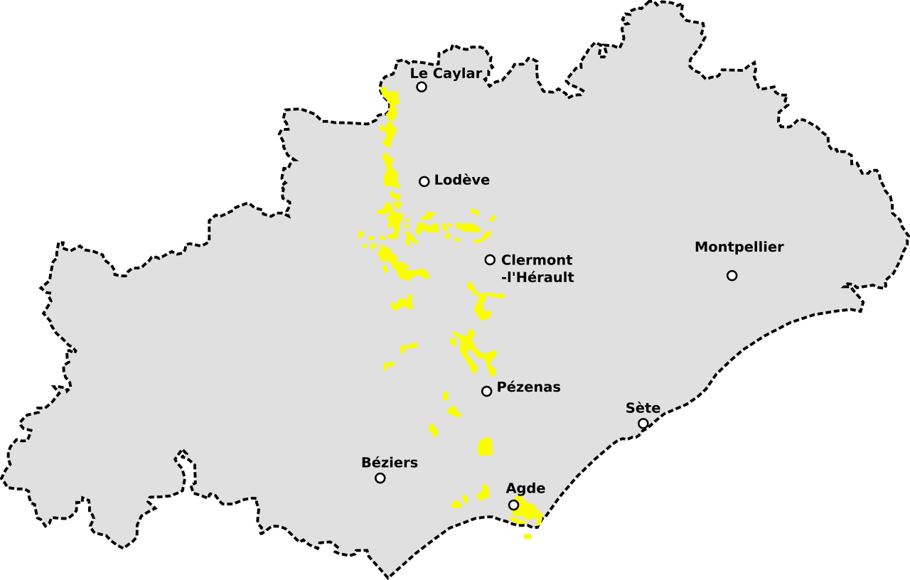
Français : Carte des coulées basaltiques (tertiaire et Quaternaire dans l'Hérault (France) |
| Date | |
| Source | dessin personnel (d'après carte géologique de l'Hérault) |
| Author | Spedona |
| SVG development |
Licensing
[edit]
I, the copyright holder of this work, hereby publish it under the following licenses:

|
Permission is granted to copy, distribute and/or modify this document under the terms of the GNU Free Documentation License, Version 1.2 or any later version published by the Free Software Foundation; with no Invariant Sections, no Front-Cover Texts, and no Back-Cover Texts. A copy of the license is included in the section entitled GNU Free Documentation License. |
This file is licensed under the Creative Commons Attribution-Share Alike 3.0 Unported license.
- You are free:
- to share – to copy, distribute and transmit the work
- to remix – to adapt the work
- Under the following conditions:
- attribution – You must give appropriate credit, provide a link to the license, and indicate if changes were made. You may do so in any reasonable manner, but not in any way that suggests the licensor endorses you or your use.
- share alike – If you remix, transform, or build upon the material, you must distribute your contributions under the same or compatible license as the original.
You may select the license of your choice.
File history
Click on a date/time to view the file as it appeared at that time.
| Date/Time | Thumbnail | Dimensions | User | Comment | |
|---|---|---|---|---|---|
| current | 14:23, 24 June 2011 | | 988 × 629 (79 KB) | Ciaurlec (talk | contribs) | Changed colours to uniform to other geological maps: yellow is for Cenozoic sedimentary in absence of a more defined colour for volcanics |
| 19:04, 14 May 2008 |  | 988 × 629 (103 KB) | Spedona (talk | contribs) | rechargt image | |
| 19:00, 14 May 2008 |  | 988 × 629 (54 KB) | Spedona (talk | contribs) | == Description == {{Information |Description=Carte des coulées basaltiques (tertiaire et Quaternaire dans l'Hérault (France) |Source=dessin personnel (d'après carte géologique de l'Hérault) |Date=13 mai 2008 |Author= Spedona |Per |
You cannot overwrite this file.
File usage on Commons
The following page uses this file:
File usage on other wikis
The following other wikis use this file:
- Usage on de.wikipedia.org
- Usage on fr.wikipedia.org