File:Carte over Christiania Havn (12), 1737.jpg
Jump to navigation
Jump to search

Size of this preview: 800 × 559 pixels. Other resolutions: 320 × 223 pixels | 640 × 447 pixels | 1,024 × 715 pixels | 1,280 × 894 pixels | 2,560 × 1,787 pixels | 6,378 × 4,453 pixels.
Original file (6,378 × 4,453 pixels, file size: 3.52 MB, MIME type: image/jpeg)
Captions
Captions
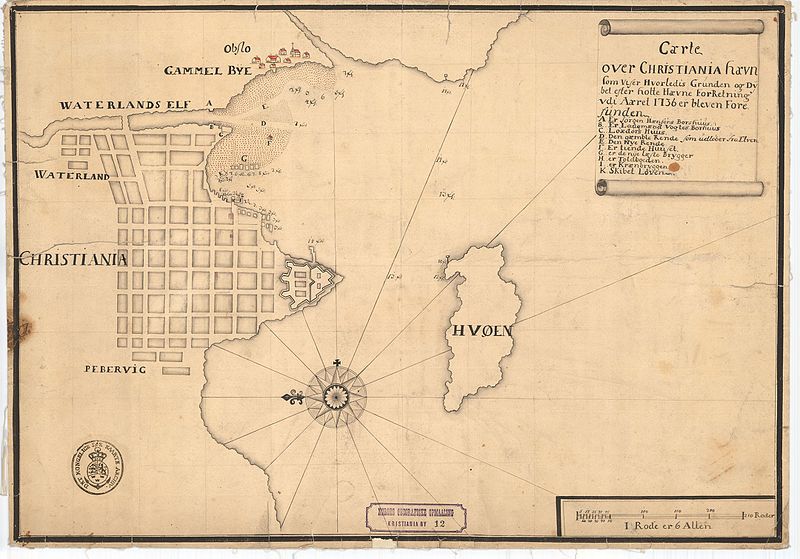
Map of the harbor of Christiania in Norway, 1737, with the Old town of Oslo (Obslo) on the opposite side of the Waterland river. In the Oslo fjord the island Huøen is prominent.
Summary
[edit],_1737.jpg&action=edit§ion=1)
| Title |
Norsk bokmål: Carte over Christiania Havn (12), 1737 |
||||||||||||||||||||||||||
| Date | |||||||||||||||||||||||||||
| Source |
|
||||||||||||||||||||||||||
| Permission (Reusing this file) |
This file is licensed under the Creative Commons Attribution 4.0 International license.
|
||||||||||||||||||||||||||
| Geotemporal data | |||||||||||||||||||||||||||
| Date depicted | |||||||||||||||||||||||||||
| Map location | Oslo,Oslo and the surroundings (Oslo,Oslo og omegn,Oslo and the surroundings) | ||||||||||||||||||||||||||
| Scale | 1:8,000 | ||||||||||||||||||||||||||
| Georeferencing | If inappropriate please set warp_status = skip to hide. | ||||||||||||||||||||||||||
| Bibliographic data | |||||||||||||||||||||||||||
| Part of the series | Category:Christiania - Kristiania - Oslo | ||||||||||||||||||||||||||
| Map sheet | 12 | ||||||||||||||||||||||||||
| Language | Norwegian | ||||||||||||||||||||||||||
| Archival data | |||||||||||||||||||||||||||
| Collection |
|
||||||||||||||||||||||||||
| Accession number | |||||||||||||||||||||||||||
| Medium | drawing | ||||||||||||||||||||||||||
File history
Click on a date/time to view the file as it appeared at that time.
| Date/Time | Thumbnail | Dimensions | User | Comment | |
|---|---|---|---|---|---|
| current | 02:44, 30 October 2015 | | 6,378 × 4,453 (3.52 MB) | Artturimatias (talk | contribs) | GWToolset: Creating mediafile for Artturimatias. |
You cannot overwrite this file.
File usage on Commons
There are no pages that use this file.
File usage on other wikis
The following other wikis use this file:
- Usage on no.wikipedia.org
,_1737.jpg&oldid=849284049)