File:Carte générale de l'Amérique septentrionale. LOC 74693193.jpg
Jump to navigation
Jump to search

Size of this preview: 800 × 580 pixels. Other resolutions: 320 × 232 pixels | 640 × 464 pixels | 1,024 × 742 pixels | 1,280 × 928 pixels | 2,560 × 1,856 pixels | 4,427 × 3,210 pixels.
Original file (4,427 × 3,210 pixels, file size: 2.17 MB, MIME type: image/jpeg)
Captions
Captions
Add a one-line explanation of what this file represents
Summary
[edit]| Description |
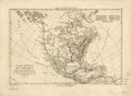
English: Scale ca. 1:38,000,000. Hand colored. Prime meridian: Ferro and Paris. Relief shown pictorially. Available also through the Library of Congress Web site as a raster image. Vault AACR2: 100; 651; 700/2 |
||
| Title | Carte générale de l'Amérique septentrionale. | ||
| Shelf ID | G3300 1781 .B6 | ||
| Date | |||
| Source | https://www.loc.gov/item/74693193/ | ||
| Author | Bonne, Rigobert; Perrier; André | ||
| Permission (Reusing this file) |
|
||
| Other versions |
|
||
| Location | North America | ||
| Part of | Military Battles And Campaigns · American Memory · Catalog · Geography And Map Division · American Revolution And Its Era: Maps And Charts Of North America And The West Indies, 1750-1789 | ||
| Subject | North America · Maps · Early Works To 1800 |

Licensing
[edit]
|
This is a faithful photographic reproduction of a two-dimensional, public domain work of art. The work of art itself is in the public domain for the following reason:
The official position taken by the Wikimedia Foundation is that "faithful reproductions of two-dimensional public domain works of art are public domain".
This photographic reproduction is therefore also considered to be in the public domain in the United States. In other jurisdictions, re-use of this content may be restricted; see Reuse of PD-Art photographs for details. | ||||
File history
Click on a date/time to view the file as it appeared at that time.
| Date/Time | Thumbnail | Dimensions | User | Comment | |
|---|---|---|---|---|---|
| current | 09:20, 2 June 2018 | | 4,427 × 3,210 (2.17 MB) | Fæ (talk | contribs) | LOC Maps https://www.loc.gov/item/74693193/ #17840 |
You cannot overwrite this file.
File usage on Commons
The following page uses this file: