File:Carte du tramway de Verneuil à Melun.svg
Jump to navigation
Jump to search

Size of this PNG preview of this SVG file: 166 × 598 pixels. Other resolutions: 66 × 240 pixels | 133 × 480 pixels | 213 × 768 pixels | 284 × 1,024 pixels | 568 × 2,048 pixels | 1,799 × 6,481 pixels.
Original file (SVG file, nominally 1,799 × 6,481 pixels, file size: 24.53 MB)
Captions
Captions
Add a one-line explanation of what this file represents
Summary
[edit]
| Description |
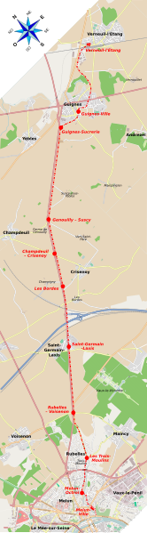
Français : Carte du tramway de Verneuil à Melun English: Map of former tramway from Verneuil-l'Étang to Melun |
| Date | |
| Source | Own work, from OpenStreetMap and list of GPS coordinates below (some information extracted from Plan de Melun 1904) |
| Author | Starus |
| Station | GPS |
|---|---|
| Verneuil-l'Étang | 48° 38′ 45,69″ N, 2° 49′ 22,21″ E |
| Guignes-Ville | 48° 37′ 58,94″ N, 2° 47′ 47,64″ E |
| Guignes-Sucrerie | 48° 38′ 0,90″ N, 2° 47′ 6,50″ E |
| Genouilly-Suscy | 48° 36′ 53,16″ N, 2° 44′ 54,97″ E |
| Champdeuil - Crisenoy | 48° 36′ 18,89″ N, 2° 44′ 21,43″ E |
| Les Bordes | 48° 35′ 44,51″ N, 2° 43′ 47,83″ E |
| Saint-Germain-Laxis | 48° 34′ 51,99″ N, 2° 42′ 43,24″ E |
| Rubelles - Voisenon | 48° 33′ 53,61″ N, 2° 41′ 27,70″ E |
| Les Trois-Moulins | 48° 33′ 5,53″ N, 2° 40′ 48,84″ E |
| Melun-Octroi | 48° 32′ 40,32″ N, 2° 39′ 57,94″ E |
| Melun-Ville | 48° 32' 16,9", N 2° 39' 55,0" E |
Licensing
[edit]
I, the copyright holder of this work, hereby publish it under the following license:
This file is licensed under the Creative Commons Attribution-Share Alike 3.0 Unported license.
- You are free:
- to share – to copy, distribute and transmit the work
- to remix – to adapt the work
- Under the following conditions:
- attribution – You must give appropriate credit, provide a link to the license, and indicate if changes were made. You may do so in any reasonable manner, but not in any way that suggests the licensor endorses you or your use.
- share alike – If you remix, transform, or build upon the material, you must distribute your contributions under the same or compatible license as the original.
File history
Click on a date/time to view the file as it appeared at that time.
| Date/Time | Thumbnail | Dimensions | User | Comment | |
|---|---|---|---|---|---|
| current | 22:39, 1 March 2014 | 1,799 × 6,481 (24.53 MB) | Starus (talk | contribs) | correction on Melun-Ville station | |
| 01:00, 24 September 2013 | 1,799 × 6,481 (24.53 MB) | Starus (talk | contribs) | correction Saint-Germain-Laxis | ||
| 15:38, 22 September 2013 | 1,799 × 6,481 (24.53 MB) | Starus (talk | contribs) | correct Rubelles/Voisenon, add some villages/hamlets, change font | ||
| 18:26, 19 September 2013 | 1,799 × 6,481 (24.53 MB) | Starus (talk | contribs) | User created page with UploadWizard |
You cannot overwrite this file.
File usage on Commons
There are no pages that use this file.
File usage on other wikis
The following other wikis use this file:
- Usage on de.wikipedia.org
- Usage on fr.wikipedia.org