File:Carte du gouvernement d'Alger comprenant l'empire de Maroc, la régence de Tunis et une partie du grand désert - par A. R. Fremin, géographe ; gravée sur acier par Bénard ; imp(rim)ée par Folliau - btv1b53088066m.jpg
Jump to navigation
Jump to search

Size of this preview: 800 × 574 pixels. Other resolutions: 320 × 229 pixels | 640 × 459 pixels | 1,024 × 734 pixels | 1,280 × 918 pixels | 2,560 × 1,836 pixels | 10,264 × 7,360 pixels.
Original file (10,264 × 7,360 pixels, file size: 11.03 MB, MIME type: image/jpeg)
Captions
Captions
Add a one-line explanation of what this file represents
Summary
[edit]| Warning | The original file is very high-resolution. It might not load properly or could cause your browser to freeze when opened at full size. |
|---|
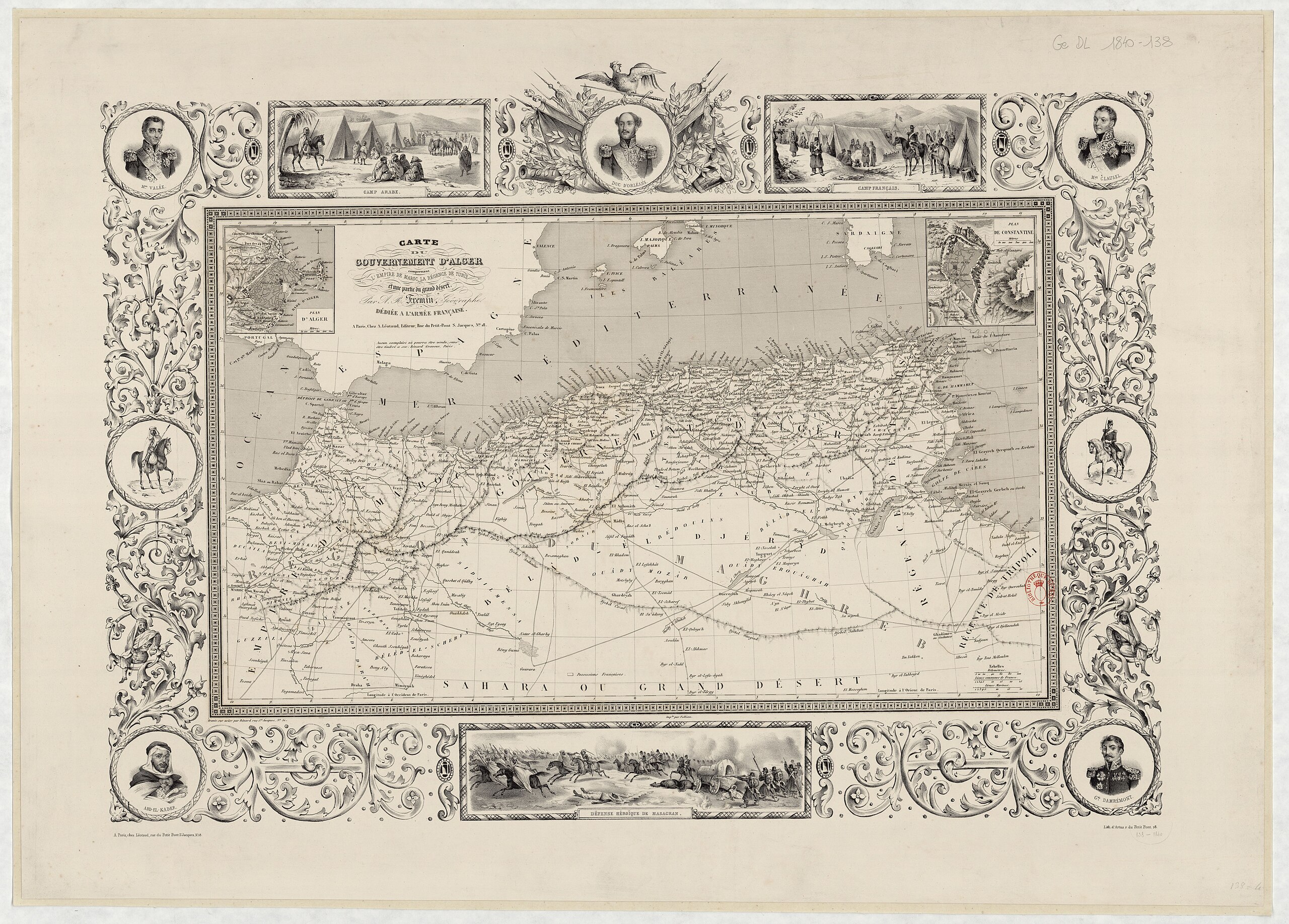
| Carte du gouvernement d'Alger comprenant l'empire de Maroc, la régence de Tunis et une partie du grand désert / par A. R. Fremin, géographe ; gravée sur acier par Bénard ; imp[rim]ée par Folliau
( |
|||||||||||||||||||||||||||
|---|---|---|---|---|---|---|---|---|---|---|---|---|---|---|---|---|---|---|---|---|---|---|---|---|---|---|---|
| Author |
Frémin, Antoine-Remy. Graveur Bénard (18..-18.. ; graveur). Graveur |
||||||||||||||||||||||||||
| Title |
Carte du gouvernement d'Alger comprenant l'empire de Maroc, la régence de Tunis et une partie du grand désert / par A. R. Fremin, géographe ; gravée sur acier par Bénard ; imp[rim]ée par Folliau |
||||||||||||||||||||||||||
| Description |
Français : Sujet : Algérie
Maroc, Royaume du -- Est Tunis, Régence de Échelle(s) : [ca 1:3 449 000], 100 km [= 2,9 cm] Couverture : Algérie Maroc Tunisie W 12°55' - E 31°15' / N 44°55' - N 22° Langue : français Éditeur : A. Léotaud (Paris) |
||||||||||||||||||||||||||
| Date | 1840 | ||||||||||||||||||||||||||
| Dimensions | height: 55.5 cm (21.8 in); width: 33 cm (12.9 in) | ||||||||||||||||||||||||||
| Collection |
|
||||||||||||||||||||||||||
| References |
Français : Notice du catalogue : http://catalogue.bnf.fr/ark:/12148/cb426961549 |
||||||||||||||||||||||||||
| Source/Photographer |
Français : Bibliothèque nationale de France, département Cartes et plans, Ge DL 1840-138
Bibliothèque nationale de France |
||||||||||||||||||||||||||
| Permission (Reusing this file) |
|
||||||||||||||||||||||||||

%C3%A9e_par_Folliau_-_btv1b53088066m.jpg&action=edit§ion=1)
%C3%A9e_par_Folliau_-_btv1b53088066m.jpg&flash=no)
File history
Click on a date/time to view the file as it appeared at that time.
| Date/Time | Thumbnail | Dimensions | User | Comment | |
|---|---|---|---|---|---|
| current | 01:19, 15 July 2022 | | 10,264 × 7,360 (11.03 MB) | Gzen92Bot (talk | contribs) | Gallica btv1b53088066m |
You cannot overwrite this file.
File usage on Commons
The following page uses this file:
%C3%A9e_par_Folliau_-_btv1b53088066m.jpg)
ée_par_Folliau_-_btv1b53088066m.jpg&oldid=849253528)