File:Carte des Landes.svg
Jump to navigation
Jump to search

Size of this PNG preview of this SVG file: 767 × 599 pixels. Other resolutions: 307 × 240 pixels | 614 × 480 pixels | 983 × 768 pixels | 1,280 × 1,000 pixels | 2,560 × 2,001 pixels | 1,222 × 955 pixels.
Original file (SVG file, nominally 1,222 × 955 pixels, file size: 373 KB)
Captions
Captions
Add a one-line explanation of what this file represents
Summary
[edit]
| Description |
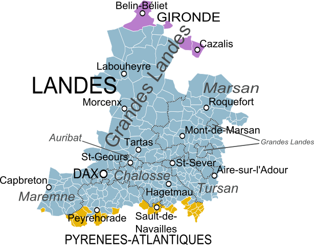
English: Map of the old province of Lannes or Landes, France, showing the communes according to the current administrative division. Français : Carte du pays des Lannes ou Landes montrant les communes et les départements actuels. |
| Date | |
| Source |
Carte du Bearn de la Bigorre, de l'Armagnac et des Pays Voisins, Guillaume Delisle. Derivative works of this file: Blank Map of Landes Department, France, with Communes.svg by Poulpy Derivative works of this file: Blank Map of Gironde Department, France, with Communes.svg by Poulpy Derivative works of this file: Blank Map of Pyrénées-Atlantiques Department, France, with Communes.svg by Poulpy |
| Author | Oie blanche |
Licensing
[edit]
I, the copyright holder of this work, hereby publish it under the following license:
This file is licensed under the Creative Commons Attribution-Share Alike 3.0 Unported license.
- You are free:
- to share – to copy, distribute and transmit the work
- to remix – to adapt the work
- Under the following conditions:
- attribution – You must give appropriate credit, provide a link to the license, and indicate if changes were made. You may do so in any reasonable manner, but not in any way that suggests the licensor endorses you or your use.
- share alike – If you remix, transform, or build upon the material, you must distribute your contributions under the same or compatible license as the original.
File history
Click on a date/time to view the file as it appeared at that time.
| Date/Time | Thumbnail | Dimensions | User | Comment | |
|---|---|---|---|---|---|
| current | 17:40, 27 March 2014 | | 1,222 × 955 (373 KB) | Oie blanche (talk | contribs) | User created page with UploadWizard |
You cannot overwrite this file.
File usage on Commons
The following page uses this file:
- File:Carte des Lannes.svg (file redirect)
File usage on other wikis
The following other wikis use this file:
- Usage on fr.wikipedia.org
- Usage on ja.wikipedia.org