File:Carte des îles de la Galite.jpg

From Wikimedia Commons, the free media repository
Jump to navigation Jump to search

Original file(3,040 × 2,047 pixels, file size: 2.93 MB, MIME type: image/jpeg)

Captions

Captions

Add a one-line explanation of what this file represents
Description
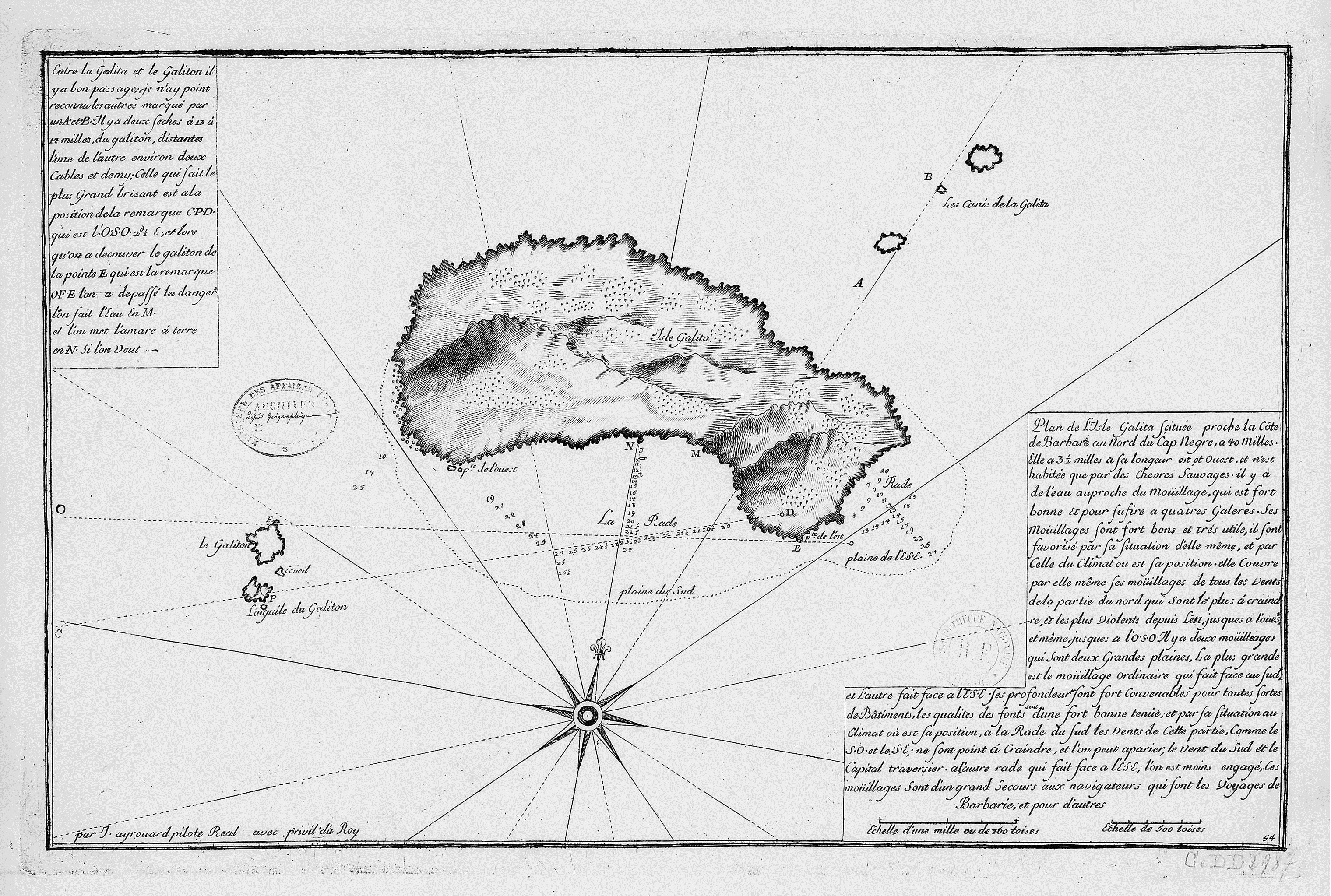
Français : "Plan de l'Isle Galita scituée proche la côte de Barbarie au nord du cap Negre": Plan de l'île de Galite, Tunisie
Date between 1700 and 1799
date QS:P,+1750-00-00T00:00:00Z/7,P1319,+1700-00-00T00:00:00Z/9,P1326,+1799-00-00T00:00:00Z/9
Source
Bibliothèque nationale de France
Author Ayrouard, Jacques (16..-17..): Cartographe
Permission
(Reusing this file)
Public domain
This work is in the public domain in France for one of the following reasons:
  • Its author (or the last of its authors in the case of a collaboration work) died more than 70 years ago (CPI art. L123-1) and did not benefit from any copyright extension (CPI art. L123-8, L123-9 and L123-10)[1];
  • It is an anonymous or pseudonymous work (the identity of the author has never been disclosed) or a collective work[2] and more than 70 years have passed since its publication (CPI art. L123-3);
  • It is the recording of an audiovisual or musical work already in the public domain, and more than 50 years have passed since the performance or the recording (CPI art. L211-4).

Please note that moral rights still apply when the work is in the public domain. They encompass, among others, the right to the respect of the author's name, quality and work (CPI art. L121-1). Attribution therefore remains mandatory.
  1. Copyright extensions must be considered only in the case of musical works and of authors Mort pour la France (died during conflict, in the service of France). In other cases, they are included in the 70 years post mortem auctoris length (see this statement of the Cour de Cassation).
  2. The collective work status is quite restrictive, please make sure that it is actually established.

العربية  English  español  français  日本語  한국어  македонски  русский  Tiếng Việt  简体中文  繁體中文  +/−

This work was first published in Tunisia and is now in the public domain because its copyright protection has expired by virtue of the Law No. 94-36 of February 24, 1994, on Literary and Artistic Property, enacted 1994, amended 2009 (more details). The work meets one of the following criteria:
  • It is an anonymous work or pseudonymous work and 50 years have passed since the date of its publication (or creation, whatever date is the latest)
  • It is a photographic work, and 50 years have passed since the date of its creation
  • It is another kind of work, and 50 years have passed since the year of death of the author (or last surviving author)
  • It is one of "official texts of legislative, administrative or legal nature and their official translations"
Before July 5, 2009, a photographic work was protected for 25 years. Pictures created before July 5, 1984 have already been placed into the public domain.

العربية  Deutsch  English  français  +/−

Previous public domain rationale, no longer applicable
Public domain

العربية  Deutsch  English  español  français  galego  italiano  日本語  македонски  Nederlands  português  русский  sicilianu  slovenščina  українська  +/−

Other versions

File history

Click on a date/time to view the file as it appeared at that time.

Date/TimeThumbnailDimensionsUserComment
current09:30, 25 August 2015Thumbnail for version as of 09:30, 25 August 20153,040 × 2,047 (2.93 MB)Ratzer (talk | contribs)(de) Höhere Auflösung<br /> (en) higher resolution
19:24, 9 October 2010Thumbnail for version as of 19:24, 9 October 2010759 × 513 (69 KB)DrFO.Jr.Tn (talk | contribs){{Information |Description={{en|1="Plan de l'Isle Galita scituée proche la côte de Barbarie au nord du cap Negre" Plan de l'île de Galite, Tunisie}} |Source=[http://gallica.bnf.fr/RequestDigitalElement?O=IFN-7759350&E=JPEG&Deb=1&Fin=1&Param=D] |Author

The following page uses this file:

File usage on other wikis

The following other wikis use this file: