File:Carte de la Nièvre.svg
Jump to navigation
Jump to search

Size of this PNG preview of this SVG file: 673 × 600 pixels. Other resolutions: 269 × 240 pixels | 539 × 480 pixels | 862 × 768 pixels | 1,150 × 1,024 pixels | 2,299 × 2,048 pixels | 898 × 800 pixels.
Original file (SVG file, nominally 898 × 800 pixels, file size: 216 KB)
Captions
Captions
Add a one-line explanation of what this file represents
Summary
[edit]
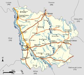
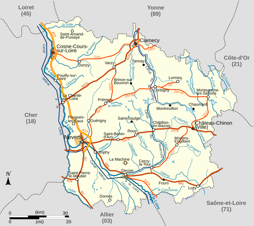
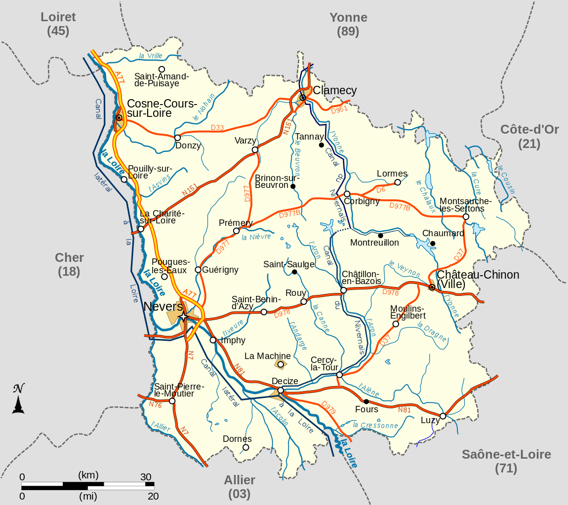
| Description | Carte du département français de la Nièvre avec réseau hydrographique et réseau routier principal |
| Date | |
| Source |
travail personnel
|
| Author | LeMorvandiau |
| Other versions |
.svg)  |
Licensing
[edit]
I, the copyright holder of this work, hereby publish it under the following licenses:

|
Permission is granted to copy, distribute and/or modify this document under the terms of the GNU Free Documentation License, Version 1.2 or any later version published by the Free Software Foundation; with no Invariant Sections, no Front-Cover Texts, and no Back-Cover Texts. A copy of the license is included in the section entitled GNU Free Documentation License. |
This file is licensed under the Creative Commons Attribution-Share Alike 3.0 Unported, 2.5 Generic, 2.0 Generic and 1.0 Generic license.
- You are free:
- to share – to copy, distribute and transmit the work
- to remix – to adapt the work
- Under the following conditions:
- attribution – You must give appropriate credit, provide a link to the license, and indicate if changes were made. You may do so in any reasonable manner, but not in any way that suggests the licensor endorses you or your use.
- share alike – If you remix, transform, or build upon the material, you must distribute your contributions under the same or compatible license as the original.
You may select the license of your choice.
File history
Click on a date/time to view the file as it appeared at that time.
| Date/Time | Thumbnail | Dimensions | User | Comment | |
|---|---|---|---|---|---|
| current | 05:36, 27 October 2008 | | 898 × 800 (216 KB) | LeMorvandiau (talk | contribs) | Normalisation générale selon les conventions cartographiques. |
| 03:50, 10 April 2008 |  | 710 × 704 (204 KB) | LeMorvandiau (talk | contribs) | == Description == {{Information |Description=Carte du département français de la Nièvre avec réseau hydrographique et réseau routier principal |Source=travail personnel |Date=9 avril 2008 |Author= LeMorvandiau |Permission= |othe | |
| 03:45, 10 April 2008 |  | 710 × 704 (204 KB) | LeMorvandiau (talk | contribs) | == Description == {{Information |Description=Carte du département français de la Nièvre avec réseau hydrographique et réseau routier principal |Source=travail personnel |Date=9 avril 2008 |Author= LeMorvandiau |Permission= |othe | |
| 04:10, 9 April 2008 |  | 801 × 896 (205 KB) | LeMorvandiau (talk | contribs) | {{Information |Description=Carte du département français de la Nièvre, avec réseau hydrographique et réseau routier principal |Source=travail personnel |Date=9 avril 2008 |Author= LeMorvandiau |Permission= |other_versions= }} [ |
You cannot overwrite this file.
File usage on Commons
The following 2 pages use this file:
File usage on other wikis
The following other wikis use this file:
- Usage on bg.wikipedia.org
- Usage on el.wikipedia.org
- Usage on en.wikipedia.org
- Usage on eo.wikipedia.org
- Usage on es.wikipedia.org
- Usage on fr.wikipedia.org
- Nièvre (département)
- Chaumard (Nièvre)
- Gien-sur-Cure
- Montsauche-les-Settons
- Lormes
- La Machine (Nièvre)
- Corbigny
- Chiddes (Nièvre)
- Fléty
- Larochemillay
- Luzy
- Millay
- Tazilly
- Château-Chinon (Campagne)
- Chevenon
- Cossaye
- Gouloux
- Lucenay-lès-Aix
- Saint-Saulge
- Beuvron (Yonne)
- Ixeure
- Canne (affluent de l'Aron)
- Réseau routier de la Nièvre
- Utilisateur:LeMorvandiau/Cartes
- Portail:Nièvre
- Portail:Nièvre/Transport
- Projet:Cartographie/Cartes standards/France
- Magny-Cours
- Vrille (rivière)
- Climat de la Nièvre
- Usage on it.wikipedia.org
- Usage on ja.wikipedia.org
- Usage on mr.wikipedia.org
- Usage on nl.wikipedia.org
- Usage on oc.wikipedia.org
View more global usage of this file.