File:Carte de la Champagne.svg
Jump to navigation
Jump to search

Size of this PNG preview of this SVG file: 606 × 600 pixels. Other resolutions: 243 × 240 pixels | 485 × 480 pixels | 776 × 768 pixels | 1,035 × 1,024 pixels | 2,070 × 2,048 pixels | 2,916 × 2,885 pixels.
Original file (SVG file, nominally 2,916 × 2,885 pixels, file size: 1.51 MB)
Captions
Captions
Add a one-line explanation of what this file represents
Summary
[edit]
| Description |
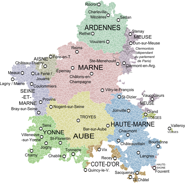
English: Map of the old province of Champagne, France, showing the communes according to the current administrative division. Français : Carte de la province de la Champagne montrant les communes et les départements actuels Русский: Карта исторической области Шампань во Франции с указанием современных департаментов и коммун |
| Date | |
| Source | Partie septentrionale du gouvernement général de Champagne où se trouvent le Retelois, le Rhemois, la Champagne propre, partie de la Brie et du Pertois, etc. et Partie méridionale du gouvernement général de Champagne qui comprend la Champagne propre, la Vallage, le Bassigny, le Senonois, et une partie de la Brie et du Perthois, Robert de Vaugondy. |
| Author | Oie blanche |
Licensing
[edit]
I, the copyright holder of this work, hereby publish it under the following license:
This file is licensed under the Creative Commons Attribution-Share Alike 3.0 Unported license.
- You are free:
- to share – to copy, distribute and transmit the work
- to remix – to adapt the work
- Under the following conditions:
- attribution – You must give appropriate credit, provide a link to the license, and indicate if changes were made. You may do so in any reasonable manner, but not in any way that suggests the licensor endorses you or your use.
- share alike – If you remix, transform, or build upon the material, you must distribute your contributions under the same or compatible license as the original.
File history
Click on a date/time to view the file as it appeared at that time.
| Date/Time | Thumbnail | Dimensions | User | Comment | |
|---|---|---|---|---|---|
| current | 23:16, 21 March 2017 | | 2,916 × 2,885 (1.51 MB) | Oie blanche (talk | contribs) | Orain en Bourgogne |
| 02:07, 14 January 2014 |  | 2,916 × 2,885 (1.51 MB) | Oie blanche (talk | contribs) | Minor edit. | |
| 07:07, 13 January 2014 |  | 2,916 × 2,885 (1.53 MB) | Oie blanche (talk | contribs) | Minor edit. | |
| 04:37, 12 January 2014 |  | 2,916 × 2,782 (1.68 MB) | Oie blanche (talk | contribs) | User created page with UploadWizard |
You cannot overwrite this file.
File usage on Commons
The following page uses this file:
File usage on other wikis
The following other wikis use this file:
- Usage on ar.wikipedia.org
- Usage on be.wikipedia.org
- Usage on br.wikipedia.org
- Usage on ca.wikipedia.org
- Usage on el.wikipedia.org
- Usage on es.wikipedia.org
- Usage on fr.wikipedia.org
- Usage on hr.wikipedia.org
- Usage on ja.wikipedia.org
- Usage on ko.wikipedia.org
- Usage on nl.wikipedia.org
- Usage on ro.wikipedia.org
- Usage on ru.wikipedia.org
- Usage on tt.wikipedia.org
- Usage on uk.wikipedia.org
- Usage on www.wikidata.org