File:Carte de l'entrée de la rivière d'Hudson, dépuis Sandy-Hook jusques à New-York avec les bancs, sondes, marques de navigation etc. LOC 73694809.jpg
Jump to navigation
Jump to search

Size of this preview: 442 × 599 pixels. Other resolutions: 177 × 240 pixels | 354 × 480 pixels | 566 × 768 pixels | 755 × 1,024 pixels | 1,510 × 2,048 pixels | 4,393 × 5,958 pixels.
Original file (4,393 × 5,958 pixels, file size: 4.93 MB, MIME type: image/jpeg)
Captions
Captions
Add a one-line explanation of what this file represents
Summary
[edit]| Description |
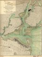
English: Scale ca. 1:70,000. Hand colored. Depths shown by soundings. Relief shown by land form drawings. Includes "Avertissement." LC Maps of North America, 1750-1789, 1230 Available also through the Library of Congress Web site as a raster image. Vault AACR2 |
||
| Title | Carte de l'entrée de la rivière d'Hudson, dépuis Sandy-Hook jusques à New-York avec les bancs, sondes, marques de navigation &c. | ||
| Shelf ID | G3802.H9 1778 .F7 | ||
| Date | |||
| Source | https://www.loc.gov/item/73694809/ | ||
| Author | France. Dépôt Des Cartes Et Plans De La Marine; Sartine, Antoine De | ||
| Permission (Reusing this file) |
|
||
| Other versions |
|
||
| Location | United States · New York (State) · New Jersey · United States · New Jersey · Hudson River. · New York · New York Harbor · New York. · Hudson River · New York (State) | ||
| Part of | Military Battles And Campaigns · American Memory · Catalog · Geography And Map Division · American Revolution And Its Era: Maps And Charts Of North America And The West Indies, 1750-1789 | ||
| Subject | Hudson River (N.Y. And N.J.) · New York Harbor (N.Y. And N.J.) · New Jersey · Nautical Charts · United States · Maps · Early Works To 1800 · New York · Hudson River · New York (State) |

Licensing
[edit]
|
This is a faithful photographic reproduction of a two-dimensional, public domain work of art. The work of art itself is in the public domain for the following reason:
The official position taken by the Wikimedia Foundation is that "faithful reproductions of two-dimensional public domain works of art are public domain".
This photographic reproduction is therefore also considered to be in the public domain in the United States. In other jurisdictions, re-use of this content may be restricted; see Reuse of PD-Art photographs for details. | ||||
File history
Click on a date/time to view the file as it appeared at that time.
| Date/Time | Thumbnail | Dimensions | User | Comment | |
|---|---|---|---|---|---|
| current | 01:21, 19 May 2018 | | 4,393 × 5,958 (4.93 MB) | Fæ (talk | contribs) | LOC Maps https://www.loc.gov/item/73694809/ #2108 |
You cannot overwrite this file.
File usage on Commons
The following page uses this file: