File:Carte d'occupation France 1815.svg
Jump to navigation
Jump to search

Size of this PNG preview of this SVG file: 632 × 600 pixels. Other resolutions: 253 × 240 pixels | 506 × 480 pixels | 809 × 768 pixels | 1,079 × 1,024 pixels | 2,158 × 2,048 pixels | 2,000 × 1,898 pixels.
Original file (SVG file, nominally 2,000 × 1,898 pixels, file size: 392 KB)
Captions
Captions
Add a one-line explanation of what this file represents
Summary
[edit]| Description |
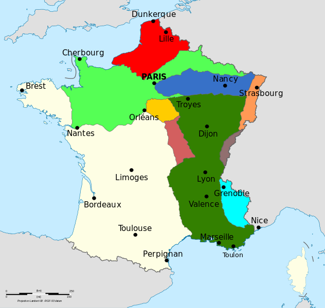
Français : Carte montrant l'occupation de la France par les Alliés entre 1815 et 1818.
Zone d'occupation de la Grande-Bretagne
Zone d'occupation de la Prusse
Zone d'occupation de la Russie
Zone d'occupation du Bade et de la Saxe
Zone d'occupation de la Bavière
Zone d'occupation de la Hesse et du Wurtemberg
Zone d'occupation de la Suisse
Zone d'occupation de la Sardaigne
Zone d'occupation de l'Autriche |
| Date | |
| Source | File:Carte d'occupation france 1815.png Ritournelle |
| Author | Augusta 89 |
| Other versions |
|

Licensing
[edit]
I, the copyright holder of this work, hereby publish it under the following license:
This file is licensed under the Creative Commons Attribution-Share Alike 3.0 Unported license.
- You are free:
- to share – to copy, distribute and transmit the work
- to remix – to adapt the work
- Under the following conditions:
- attribution – You must give appropriate credit, provide a link to the license, and indicate if changes were made. You may do so in any reasonable manner, but not in any way that suggests the licensor endorses you or your use.
- share alike – If you remix, transform, or build upon the material, you must distribute your contributions under the same or compatible license as the original.
File history
Click on a date/time to view the file as it appeared at that time.
| Date/Time | Thumbnail | Dimensions | User | Comment | |
|---|---|---|---|---|---|
| current | 21:05, 1 July 2014 | | 2,000 × 1,898 (392 KB) | Augusta 89 (talk | contribs) | User created page with UploadWizard |
You cannot overwrite this file.
File usage on Commons
The following page uses this file:
File usage on other wikis
The following other wikis use this file:
- Usage on fr.wikipedia.org
- Usage on it.wikipedia.org
- Usage on ru.wikipedia.org