File:Carte Transilien Paris-Montparnasse.svg

Original file (SVG file, nominally 1,200 × 650 pixels, file size: 178 KB)
Captions
Captions
Summary
[edit]
| Description |
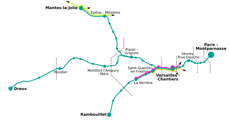
English: Map of the "Transilien Paris-Montparnasse" railway network, in western Paris suburbs, France.
Français : Carte du réseau feroviaire Transilien Paris-Montparnasse, dans la banlieue ouest de Paris, France. Les zones Carte Orange sont représentées, de même que les autres lignes RER / Transilien. |
| Date | |
| Source | travail personnel (own work) ; based on public domain geographical data. |
| Author | Benjism89, Pymouss44 |
Licensing
[edit]

|
Permission is granted to copy, distribute and/or modify this document under the terms of the GNU Free Documentation License, Version 1.2 or any later version published by the Free Software Foundation; with no Invariant Sections, no Front-Cover Texts, and no Back-Cover Texts. A copy of the license is included in the section entitled GNU Free Documentation License. |
- You are free:
- to share – to copy, distribute and transmit the work
- to remix – to adapt the work
- Under the following conditions:
- attribution – You must give appropriate credit, provide a link to the license, and indicate if changes were made. You may do so in any reasonable manner, but not in any way that suggests the licensor endorses you or your use.
- share alike – If you remix, transform, or build upon the material, you must distribute your contributions under the same or compatible license as the original.
Although this is not compulsory, I'm always glad to read that my work is useful to others. If you could send me an e-mail at benji dot wiki at gmail dot com to inform me that you are using my work, I'd be delighted. Thanks a lot!
Envie d'utiliser cette image en dehors des projets Wikimedia ? N'hésitez pas ! Cette image est placée sous licence libre de façon à ce que vous puissiez l'utiliser librement, sans avoir besoin d'une autorisation de ma part. Tout ce que vous devez faire, c'est respecter les termes de la licence et me créditer ainsi :
Bien que ce ne soit pas obligatoire, je suis toujours ravi d'apprendre que mon travail a été utile à d'autres. Si vous pouviez m'envoyer un courriel à benji point wiki arobase gmail point com pour m'informer du fait que vous utilisez mon travail, ce serait top. Merci d'avance !
File history
Click on a date/time to view the file as it appeared at that time.
| Date/Time | Thumbnail | Dimensions | User | Comment | |
|---|---|---|---|---|---|
| current | 18:59, 26 July 2011 | | 1,200 × 650 (178 KB) | Pic-Sou (talk | contribs) | erreur |
| 18:58, 26 July 2011 |  | 1,200 × 650 (178 KB) | Pic-Sou (talk | contribs) | Mantes-Sation n'est pas desservie par le transilien N | |
| 08:10, 23 June 2008 |  | 1,200 × 650 (176 KB) | Benjism89 (talk | contribs) | {{Information |Description={{en|1=Map of the "Transilien Paris-Montparnasse" railway network, in western Paris suburbs, France.}} {{fr|1=Carte du réseau feroviaire Transilien Paris-Montparnasse, dans la banlieue ouest de Paris, France. Les zones Carte Or |
You cannot overwrite this file.
File usage on Commons
There are no pages that use this file.
File usage on other wikis
The following other wikis use this file:
- Usage on en.wikipedia.org
- Usage on eo.wikipedia.org
- Usage on fr.wikipedia.org
- Usage on ja.wikipedia.org
- Usage on nl.wikipedia.org