File:Carte LGV Sud-Loire.png
Jump to navigation
Jump to search
No higher resolution available.
Carte_LGV_Sud-Loire.png (546 × 435 pixels, file size: 55 KB, MIME type: image/png)
Captions
Captions
Add a one-line explanation of what this file represents
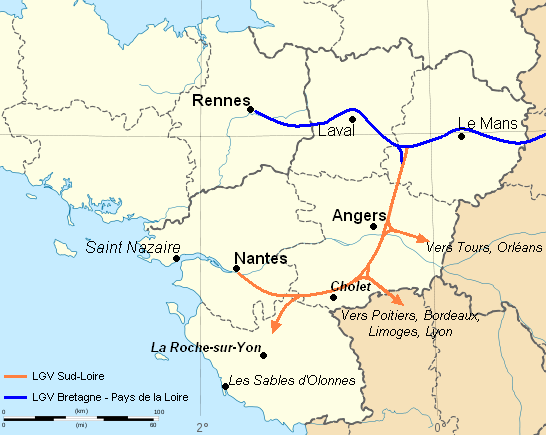
| Description | Tracé de la LGV Sud-Loire : Paris à Nantes via Angers Scale: 1:2,000,000 |
| Date | (UTC) |
| Source | |
| Author |
|
| This is a retouched picture, which means that it has been digitally altered from its original version. The original can be viewed here: France - Grand Ouest - map-blank.svg:
|
I, the copyright holder of this work, hereby publish it under the following license:
This file is licensed under the Creative Commons Attribution-Share Alike 3.0 Unported license.
- You are free:
- to share – to copy, distribute and transmit the work
- to remix – to adapt the work
- Under the following conditions:
- attribution – You must give appropriate credit, provide a link to the license, and indicate if changes were made. You may do so in any reasonable manner, but not in any way that suggests the licensor endorses you or your use.
- share alike – If you remix, transform, or build upon the material, you must distribute your contributions under the same or compatible license as the original.
Original upload log
[edit]
This image is a derivative work of the following images:
- File:France - Grand Ouest - map-blank.svg licensed with Cc-by-sa-3.0
- 2010-01-06T19:36:26Z Sémhur 736x624 (462902 Bytes) == {{int:filedesc}} == {{Information |Description={{en|Blank map of ''Grand Ouest'' (Great West) region in [[:en:France|France]] : Basse-Normandie, Bretagne, Pays-de-Loire.}} {{fr|Carte muette du [[:fr:Grand Ouest|Grand Ouest
Uploaded with derivativeFX
File history
Click on a date/time to view the file as it appeared at that time.
| Date/Time | Thumbnail | Dimensions | User | Comment | |
|---|---|---|---|---|---|
| current | 19:22, 18 September 2010 | | 546 × 435 (55 KB) | Alienor a (talk | contribs) | {{Information |Description=Tracé de la LGV Sud-Loire : Paris à Nantes via Angers Scale: 1:2,000,000 |Source=*File:France - Grand Ouest - map-blank.svg |Date=2010-09-18 19:11 (UTC) |Author=*File:France - Grand Ouest - map-blank.svg: *[[:File: |
You cannot overwrite this file.
File usage on Commons
There are no pages that use this file.