File:Carte Indus.jpg
From Wikimedia Commons, the free media repository
Jump to navigation
Jump to search
Carte_Indus.jpg (502 × 599 pixels, file size: 85 KB, MIME type: image/jpeg)
File information
Structured data
Captions
Captions
Add a one-line explanation of what this file represents
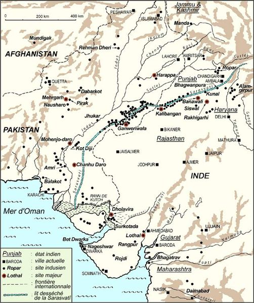
Verspreiding van de tot nu toe verrichte 1052 opgravingen van de Indusbeschaving
சிந்து சமவெளி பற்றிய வரைபடம்
Summary
[edit]| DescriptionCarte Indus.jpg |
Français : carte de l'emplacement des sites de la civilisation de l'Indus
English: Detailed map of Indus Valley Civilization settlements. Key: ville actuelle - modern cities; site indusien - Indus Valley Civilization site; site majeur - major site |
| Date | 20 January 2004 (original upload date) |
| Source |
|
| Author | The original uploader was Nataraja at French Wikipedia. |
| Permission (Reusing this file) |
statut : sous copyright, © Michel Danino, reproduite par permission (cf Page de discussion) |
Licensing
[edit]
|
The copyright holder of this file allows anyone to use it for any purpose, provided that the copyright holder is properly attributed. Redistribution, derivative work, commercial use, and all other use is permitted. |
|
Attribution |
Original upload log
[edit](All user names refer to fr.wikipedia)
- 2004-01-20 15:11 Nataraja 631×753×8 (101410 bytes) carte de la civilisation de l'Indus
File history
Click on a date/time to view the file as it appeared at that time.
| Date/Time | Thumbnail | Dimensions | User | Comment | |
|---|---|---|---|---|---|
| current | 19:38, 4 March 2007 |  | 502 × 599 (85 KB) | Merikanto~commonswiki (talk | contribs) | {{Information |Description= |Source=fr wikipedia, nl wikipedia http://nl.wikipedia.org/wiki/Afbeelding:Carte_Indus.jpg |Date=4.3.2007 |Author=n/a |Permission={{GFDL}} |other_versions= }} |
You cannot overwrite this file.
File usage on Commons
The following 3 pages use this file:
File usage on other wikis
The following other wikis use this file:
- Usage on af.wikipedia.org
- Usage on ar.wikipedia.org
- Usage on arz.wikipedia.org
- Usage on ast.wikipedia.org
- Usage on bn.wikipedia.org
- Usage on ca.wikipedia.org
- Usage on en.wikipedia.org
- Usage on en.wikiquote.org
- Usage on fa.wikipedia.org
- Usage on fi.wikipedia.org
- Usage on fi.wikibooks.org
- Usage on fr.wikipedia.org
- Usage on hu.wikipedia.org
- Usage on it.wikipedia.org
- Usage on ja.wikipedia.org
- Usage on ne.wikipedia.org
- Usage on nl.wikipedia.org
- Usage on pl.wikipedia.org
- Usage on pnb.wikipedia.org
- Usage on pt.wikibooks.org
- Usage on ta.wikipedia.org
- Usage on te.wikipedia.org
- Usage on uk.wikipedia.org
- Usage on www.wikidata.org
- Usage on zh.wikipedia.org
Metadata
This file contains additional information such as Exif metadata which may have been added by the digital camera, scanner, or software program used to create or digitize it. If the file has been modified from its original state, some details such as the timestamp may not fully reflect those of the original file. The timestamp is only as accurate as the clock in the camera, and it may be completely wrong.
| _error | 0 |
|---|
