File:Carte Cantons Arr. Chambéry.png
Jump to navigation
Jump to search

Size of this preview: 752 × 600 pixels. Other resolutions: 301 × 240 pixels | 602 × 480 pixels | 963 × 768 pixels | 1,280 × 1,021 pixels | 2,560 × 2,042 pixels | 4,704 × 3,752 pixels.
Original file (4,704 × 3,752 pixels, file size: 14.14 MB, MIME type: image/png)
Captions
Captions
Add a one-line explanation of what this file represents
Summary
[edit]
| Description |
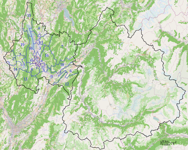
English: Map of the French department of Savoie. Are visible the 22 "cantons" (in blue) of the "arrondissement de Chambéry" (commune in red).
Note: The division limits of Chambéry and Aix-les-Bains were drawn approximative. Français : Carte du département français de la Savoie. Y sont visibles les 22 cantons (en bleu) de l'arrondissement de Chambéry (commune en rouge). Note: Les limites des cantons divisant Chambéry et Aix-les-Bains ont été tracées de manière approximative. |
|||
| Date | ||||
| Source | Own work | |||
| Author |
Open Street Map contributors / Contributeurs à Open Street Map + Florian Pépellin for the borders / Florian Pépellin pour les limites et frontières |
|||
| Permission (Reusing this file) |
OpenStreetMap data is available under the Open Database License (details). Map tiles are licensed under the Creative Commons Attribution-ShareAlike 2.0 license (CC-BY-SA 2.0).
|
Licensing
[edit]
This file is licensed under the Creative Commons Attribution-Share Alike 2.0 Generic license.
- You are free:
- to share – to copy, distribute and transmit the work
- to remix – to adapt the work
- Under the following conditions:
- attribution – You must give appropriate credit, provide a link to the license, and indicate if changes were made. You may do so in any reasonable manner, but not in any way that suggests the licensor endorses you or your use.
- share alike – If you remix, transform, or build upon the material, you must distribute your contributions under the same or compatible license as the original.
File history
Click on a date/time to view the file as it appeared at that time.
| Date/Time | Thumbnail | Dimensions | User | Comment | |
|---|---|---|---|---|---|
| current | 18:55, 22 May 2013 | | 4,704 × 3,752 (14.14 MB) | Floflo (talk | contribs) | New version |
| 10:17, 22 May 2013 |  | 4,704 × 3,752 (14.14 MB) | Floflo (talk | contribs) | {{Information |Description={{en|1=Map of the French department of Savoie. Are visible the 22 "cantons" (in blue) of the "arrondissement de Chambéry" (commune in red).}} {{fr|1=Carte du département français de la Savoie.... |
You cannot overwrite this file.
File usage on Commons
There are no pages that use this file.
File usage on other wikis
The following other wikis use this file:
- Usage on fr.wikipedia.org
- Usage on ro.wikipedia.org