File:Carta Maritima de la Isla de Cuba, que Comprehende las Juridicciones de Filipina, la Havana, las quatro Villas, la de la Villa del Puerto del Principe, el Bayamo y la de la Ciudad de Cuba LOC 2010587904.jpg
Jump to navigation
Jump to search

Size of this preview: 800 × 354 pixels. Other resolutions: 320 × 142 pixels | 640 × 283 pixels | 1,024 × 453 pixels | 1,280 × 566 pixels | 2,560 × 1,133 pixels | 14,847 × 6,569 pixels.
Original file (14,847 × 6,569 pixels, file size: 11.28 MB, MIME type: image/jpeg)
Captions
Captions
Add a one-line explanation of what this file represents
Summary
[edit]| Warning | The original file is very high-resolution. It might not load properly or could cause your browser to freeze when opened at full size. |
|---|
| Description |
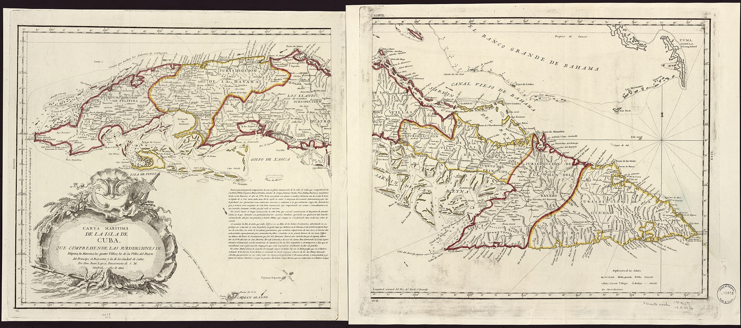
English: Relief shown pictorially. In upper left corner: Norte. Available also through the Library of Congress Web site as a raster image. |
||
| Title | Carta Maritima de la Isla de Cuba, que Comprehende las Juridicciones de Filipina, la Havana, las quatro Villas, la de la Villa del Puerto del Principe, el Bayamo y la de la Ciudad de Cuba | ||
| Shelf ID | G4920 1825 .L6 G4920 1825 .L6 | ||
| Date | |||
| Source | https://www.loc.gov/item/2010587904/ | ||
| Author | López, Juan | ||
| Permission (Reusing this file) |
|
||
| Other versions |
|
||
| Location | Cuba | ||
| Part of | American Memory · General Maps · Catalog · Geography And Map Division | ||
| Subject | Maps · Cuba |

Licensing
[edit]
|
This is a faithful photographic reproduction of a two-dimensional, public domain work of art. The work of art itself is in the public domain for the following reason:
The official position taken by the Wikimedia Foundation is that "faithful reproductions of two-dimensional public domain works of art are public domain".
This photographic reproduction is therefore also considered to be in the public domain in the United States. In other jurisdictions, re-use of this content may be restricted; see Reuse of PD-Art photographs for details. | ||||
File history
Click on a date/time to view the file as it appeared at that time.
| Date/Time | Thumbnail | Dimensions | User | Comment | |
|---|---|---|---|---|---|
| current | 14:44, 17 May 2018 | | 14,847 × 6,569 (11.28 MB) | Fæ (talk | contribs) | LOC Maps https://www.loc.gov/item/2010587904/ #10241 |
You cannot overwrite this file.
File usage on Commons
The following page uses this file: