File:Carl Zimmermann, Versuch einer Construction der Karte von Galiläa (FL19569712 3705620).jpg
Jump to navigation
Jump to search

Size of this preview: 513 × 599 pixels. Other resolutions: 205 × 240 pixels | 411 × 480 pixels | 658 × 768 pixels | 877 × 1,024 pixels | 1,753 × 2,048 pixels | 13,984 × 16,332 pixels.
Original file (13,984 × 16,332 pixels, file size: 294.98 MB, MIME type: image/jpeg)
Captions
Captions
Add a one-line explanation of what this file represents
Summary
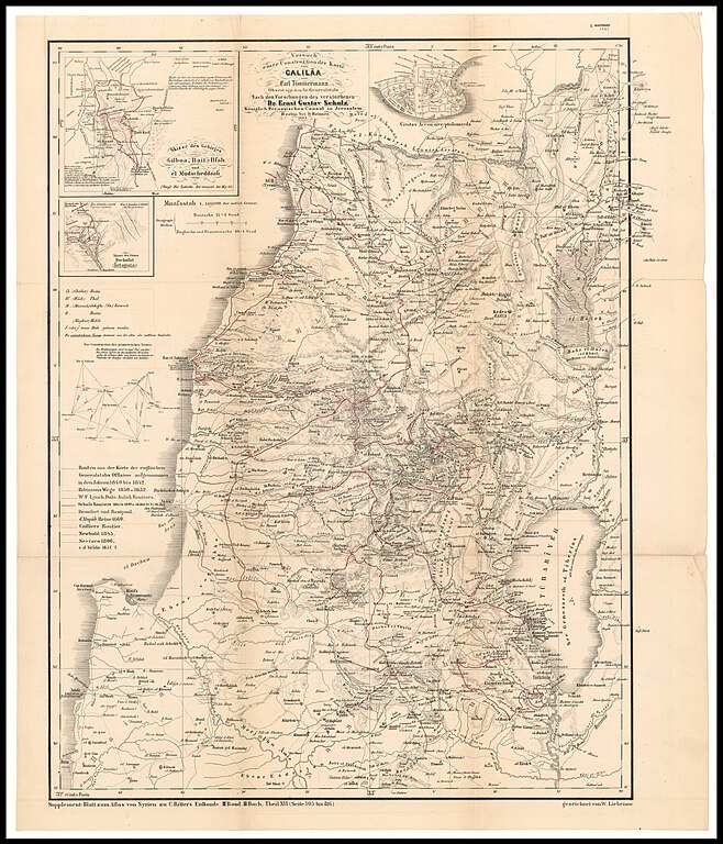
[edit]| Carl Zimmermann: Versuch einer Construction der Karte von Galiläa
( |
||||||||||||||||||||||||
|---|---|---|---|---|---|---|---|---|---|---|---|---|---|---|---|---|---|---|---|---|---|---|---|---|
| Artist |
|
|||||||||||||||||||||||
| Title |
Versuch einer Construction der Karte von Galiläa |
|||||||||||||||||||||||
| Publisher |
D.Reimer |
|||||||||||||||||||||||
| Description |
Versuch einer Construction der Karte von Galiläa. von Carl Zimmermann ... Nach den Forschungen des verstorbenen Dr. Ernst Gustav Schulz Königlich Preussischen Consul in Jerusalem. |
|||||||||||||||||||||||
| Language | German | |||||||||||||||||||||||
| Publication date | 1861 | |||||||||||||||||||||||
| Medium | 1 sheet ; | |||||||||||||||||||||||
| Dimensions | height: 66 cm (25.9 in); width: 56 cm (22 in) | |||||||||||||||||||||||
| Collection |
|
|||||||||||||||||||||||
| Current location |
|
|||||||||||||||||||||||
| Place of publication | Berlin | |||||||||||||||||||||||
| Notes | Insets: -- Skizze des Gebirges Gilboa, Bait-Ilfah und el Mudscheddaah -- Skizze des Felsen Dschafat (Iotapata).; Supplement-Blatt zum Atlas von Syrien zu C.Ritter's Erdkunde. III Band, III Buch, Theil XVI (Seite 705-816). gezeichnet von W.Liebenow.; From: Geographische Analyse zu dem Versuch einer Construction der Karte von Galiläa. Berlin, D.Reimer, 1861. In pocket. 2009 B 3719. | |||||||||||||||||||||||
| scale | 1:150,000 cm | |||||||||||||||||||||||
| IE PID | IE19569710 | |||||||||||||||||||||||
| Rosetta filename | FL19569712 | |||||||||||||||||||||||
| NNL item ID (P3959) | 990037056200205171 | |||||||||||||||||||||||
| search Merhav catalog | German, Carl Zimmermann, Berlin | |||||||||||||||||||||||
| search Merhav catalog | D.Reimer | |||||||||||||||||||||||
| Source/Photographer |
|
|||||||||||||||||||||||
| Other versions | ||||||||||||||||||||||||
| Jpg / Tif version |
|
|||||||||||||||||||||||

.jpg)

.jpg&action=edit§ion=1)
Licensing
[edit].jpg&action=edit§ion=2)
The copyright situation of this work is theoretically uncertain, because in the country of origin copyright lasts 70 years after the death of the author, and the date of the author's death is unknown. However, the date of creation of the work was over 120 years ago, and it is thus a reasonable assumption that the copyright has expired (see here for the community discussion). Do not use this template if the date of death of the author is known.
| |
| This file has been identified as being free of known restrictions under copyright law, including all related and neighboring rights. | |
File history
Click on a date/time to view the file as it appeared at that time.
| Date/Time | Thumbnail | Dimensions | User | Comment | |
|---|---|---|---|---|---|
| current | 15:38, 1 September 2023 | | 13,984 × 16,332 (294.98 MB) | Geagea (talk | contribs) | c:User:Rillke/bigChunkedUpload.js: =={{int:filedesc}}== {{Artwork |artist = {{Creator|wikidata=Q20183400}} |author = |title = Versuch einer Construction der Karte von Galiläa |description = Versuch einer Construction der Karte von Galiläa. von Carl Zimmermann ... Nach den Forschungen des verstorbenen Dr. Ernst Gustav Schulz Königlich Preussischen Consul in Jerusalem. |language = {{Label|1=Q188}} |date = |publication date = 1861 |medium = 1 sheet ; |dimensions = {{size|cm|66|56... |
You cannot overwrite this file.
File usage on Commons
The following page uses this file:
.jpg&oldid=848602637)