File:Carl Zimmermann, Terrainkarte von Jerusalem und Umgebung vor der Besiedelung (FL51415413 2761974).jpg
Jump to navigation
Jump to search

Size of this preview: 459 × 599 pixels. Other resolutions: 184 × 240 pixels | 368 × 480 pixels | 589 × 768 pixels | 785 × 1,024 pixels | 1,570 × 2,048 pixels | 11,764 × 15,347 pixels.
Original file (11,764 × 15,347 pixels, file size: 267.35 MB, MIME type: image/jpeg)
Captions
Captions
Add a one-line explanation of what this file represents
Summary
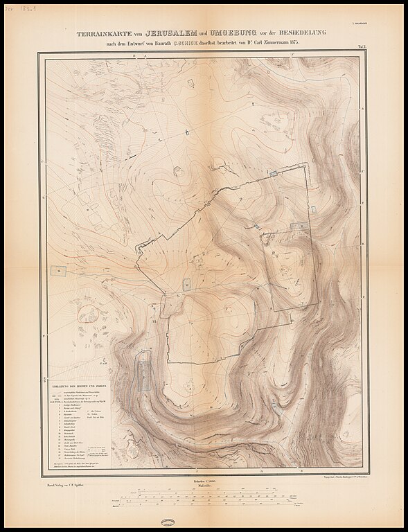
[edit]| Carl Zimmermann: Terrainkarte von Jerusalem und Umgebung vor der Besiedelung
( |
||||||||||||||||||||||||
|---|---|---|---|---|---|---|---|---|---|---|---|---|---|---|---|---|---|---|---|---|---|---|---|---|
| Artist |
| |||||||||||||||||||||||
| Contributors | Wurster, Radegger & Cie. Schick, Conrad, 1822-1901 | |||||||||||||||||||||||
| Title |
Terrainkarte von Jerusalem und Umgebung vor der Besiedelung |
|||||||||||||||||||||||
| Publisher |
Spittler |
|||||||||||||||||||||||
| Description |
Terrainkarte von Jerusalem und Umgebung vor der Besiedelung. nach dem Entwurf von Baurath C.Schick . bearbeitet von Dr. Carl Zimmermann. |
|||||||||||||||||||||||
| Language | German | |||||||||||||||||||||||
| Publication date | 1876 | |||||||||||||||||||||||
| Dimensions | height: 51 cm (20 in); width: 40 cm (15.7 in) | |||||||||||||||||||||||
| Collection |
|
|||||||||||||||||||||||
| Current location |
|
|||||||||||||||||||||||
| Place of publication | Basel | |||||||||||||||||||||||
| search Merhav catalog | Basel | |||||||||||||||||||||||
| Notes | From: Zimmermann, Carl. Karte und Plaene zur Topographie des Alten Jerusalem. Basel, 1876 (34 B 943 - Portfolio).; Topogr. Anst. v. Wurnster, Randegger & C.ie in Winterthur.; Plan drawn after Schick and corrected by Zimmermann; Taf.I | |||||||||||||||||||||||
| scale | 1:5,000 cm | |||||||||||||||||||||||
| IE PID | IE51415411 | |||||||||||||||||||||||
| Rosetta filename | FL51415413 | |||||||||||||||||||||||
| NNL item ID (P3959) | 990027619740205171 | |||||||||||||||||||||||
| search Merhav catalog | German, Carl Zimmermann | |||||||||||||||||||||||
| search Merhav catalog | Spittler | |||||||||||||||||||||||
| Source/Photographer |
|
|||||||||||||||||||||||
| Other versions | ||||||||||||||||||||||||
| Jpg / Tif version |
|
|||||||||||||||||||||||

.jpg)

.jpg&action=edit§ion=1)
Licensing
[edit].jpg&action=edit§ion=2)
The copyright situation of this work is theoretically uncertain, because in the country of origin copyright lasts 70 years after the death of the author, and the date of the author's death is unknown. However, the date of creation of the work was over 120 years ago, and it is thus a reasonable assumption that the copyright has expired (see here for the community discussion). Do not use this template if the date of death of the author is known.
| |
| This file has been identified as being free of known restrictions under copyright law, including all related and neighboring rights. | |
File history
Click on a date/time to view the file as it appeared at that time.
| Date/Time | Thumbnail | Dimensions | User | Comment | |
|---|---|---|---|---|---|
| current | 15:09, 4 September 2023 | | 11,764 × 15,347 (267.35 MB) | Geagea (talk | contribs) | pattypan 22.03 |
You cannot overwrite this file.
File usage on Commons
The following page uses this file:
.jpg&oldid=848602635)