File:Carl Zimmermann, Durchschnitts-Profile zu den Terrainkarten I U. II (FL164011347 2368221).jpg
Jump to navigation
Jump to search

Size of this preview: 770 × 600 pixels. Other resolutions: 308 × 240 pixels | 617 × 480 pixels | 987 × 768 pixels | 1,280 × 997 pixels | 2,560 × 1,993 pixels | 15,316 × 11,925 pixels.
Original file (15,316 × 11,925 pixels, file size: 169.33 MB, MIME type: image/jpeg)
Captions
Captions
Add a one-line explanation of what this file represents
Summary
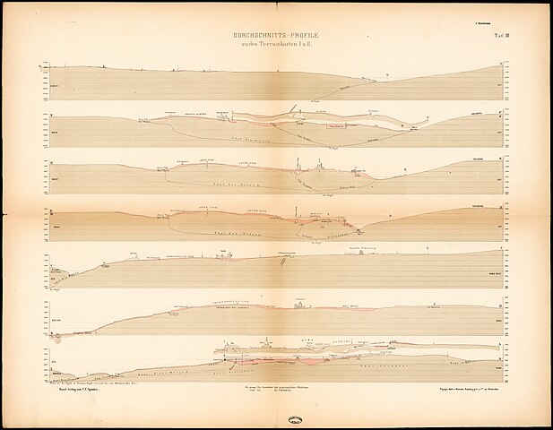
[edit]| Carl Zimmermann: Durchschnitts-Profile zu den Terrainkarten I U. II
( |
||||||||||||||||||||||||
|---|---|---|---|---|---|---|---|---|---|---|---|---|---|---|---|---|---|---|---|---|---|---|---|---|
| Artist |
| |||||||||||||||||||||||
| Contributors | Wurster, Radegger & Cie. | |||||||||||||||||||||||
| Title |
Durchschnitts-Profile zu den Terrainkarten I U. II |
|||||||||||||||||||||||
| Publisher |
Spittler |
|||||||||||||||||||||||
| Description |
Durchschnitts-Profile zu den Terrainkarten I U. II. Topogr. Anst. v. Wurster Randegger & C. ie in Winterthur. |
|||||||||||||||||||||||
| Language | German | |||||||||||||||||||||||
| Publication date | 1876 | |||||||||||||||||||||||
| Dimensions | 362 × 527 mm (14.25 × 20.74 in) | |||||||||||||||||||||||
| Collection |
|
|||||||||||||||||||||||
| Current location |
|
|||||||||||||||||||||||
| Place of publication | Basel | |||||||||||||||||||||||
| search Merhav catalog | Basel | |||||||||||||||||||||||
| Notes | From: Zimmermann, Carl. Karte und Plaene zur Topographie des Alten Jerusalem. Basel, 1876 (34 B 943 - Portfolio); Taf.III; Elevation profile, a topographic profile of old Jerusalem. חתך אורך, פרופיל גובה. | |||||||||||||||||||||||
| IE PID | IE164011345 | |||||||||||||||||||||||
| Rosetta filename | FL164011347 | |||||||||||||||||||||||
| NNL item ID (P3959) | 990023682210205171 | |||||||||||||||||||||||
| search Merhav catalog | German, Carl Zimmermann | |||||||||||||||||||||||
| search Merhav catalog | Spittler | |||||||||||||||||||||||
| Source/Photographer |
|
|||||||||||||||||||||||
| Other versions | ||||||||||||||||||||||||
| Jpg / Tif version |
|
|||||||||||||||||||||||

.jpg)

.jpg&action=edit§ion=1)
Licensing
[edit].jpg&action=edit§ion=2)
The copyright situation of this work is theoretically uncertain, because in the country of origin copyright lasts 70 years after the death of the author, and the date of the author's death is unknown. However, the date of creation of the work was over 120 years ago, and it is thus a reasonable assumption that the copyright has expired (see here for the community discussion). Do not use this template if the date of death of the author is known.
| |
| This file has been identified as being free of known restrictions under copyright law, including all related and neighboring rights. | |
File history
Click on a date/time to view the file as it appeared at that time.
| Date/Time | Thumbnail | Dimensions | User | Comment | |
|---|---|---|---|---|---|
| current | 01:44, 28 July 2023 | | 15,316 × 11,925 (169.33 MB) | Geagea (talk | contribs) | pattypan 22.03 |
You cannot overwrite this file.
File usage on Commons
The following page uses this file:
.jpg&oldid=848602626)