File:Capper Pass - geograph.org.uk - 444192.jpg
Original file (490 × 640 pixels, file size: 149 KB, MIME type: image/jpeg)
Captions
Captions
Summary
[edit]
| Description |
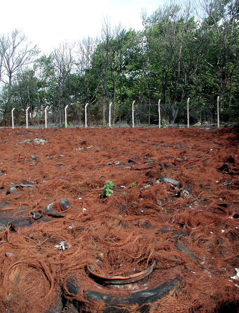
English: Capper Pass, Melton, East Riding of Yorkshire, England. On Monday 20th November 2006 the BBC local news programme Look North reported that firefighters were attending because a field of discarded tyres had been set ablaze at the old Capper Pass works on Brickyard Lane, Melton. Three days previously, I had photographed the field for Geograph: 280435 This is what the field looks like six months on. Pollution on this site is nothing new. The Capper Pass tin smelter produced over 100,000 tonnes of tin per year between 1967 and 1991 and discharged vast quantities of toxic byproducts into the air and the River Humber. During the plant's life a disproportionate number of children in West Hull villages were found to be suffering from cancer. Lead and arsenic was found in cattle grazing nearby, meaning livestock and crops had to be condemned on several farms. The British Ministry of Agriculture, Fisheries and Food (MAFF) found up to six times higher arsenic levels in river fish than anywhere else in British estuary waters. In June 2000 former owners Rio Tinto offered financial settlements to workers who were not properly protected from exposure to lead, arsenic, cadmium and radioactive substances. The site was decommissioned in 1995 but is still said to be contaminated. http://www.hullwebs.co.uk/content/m-21c/newspapers/cappa-pass.htm |
| Date | |
| Source | From geograph.org.uk |
| Author | Paul Glazzard |
| Permission (Reusing this file) |
Creative Commons Attribution Share-alike license 2.0 |
| Attribution (required by the license) | Paul Glazzard / Capper Pass / |
| Camera location | | View this and other nearby images on: OpenStreetMap |
|---|
_heading:337.00&language=en)
| Object location | | View this and other nearby images on: OpenStreetMap |
|---|
_heading:337.00&language=en)
Licensing
[edit]

|
This image was taken from the Geograph project collection. See this photograph's page on the Geograph website for the photographer's contact details. The copyright on this image is owned by Paul Glazzard and is licensed for reuse under the Creative Commons Attribution-ShareAlike 2.0 license.
|
- You are free:
- to share – to copy, distribute and transmit the work
- to remix – to adapt the work
- Under the following conditions:
- attribution – You must give appropriate credit, provide a link to the license, and indicate if changes were made. You may do so in any reasonable manner, but not in any way that suggests the licensor endorses you or your use.
- share alike – If you remix, transform, or build upon the material, you must distribute your contributions under the same or compatible license as the original.
File history
Click on a date/time to view the file as it appeared at that time.
| Date/Time | Thumbnail | Dimensions | User | Comment | |
|---|---|---|---|---|---|
| current | 10:50, 4 February 2011 | | 490 × 640 (149 KB) | GeographBot (talk | contribs) | == {{int:filedesc}} == {{Information |description={{en|1=Capper Pass On Monday 20th November 2006 the BBC local news programme Look North reported that firefighters were attending because a field of discarded tyres had been set ablaze at the old Capper Pa |
You cannot overwrite this file.
File usage on Commons
There are no pages that use this file.